Wednesday Oct 21, 2026
Wednesday Oct 21, 2026
Monday, 31 August 2026 00:25 - - {{hitsCtrl.values.hits}}

What happened
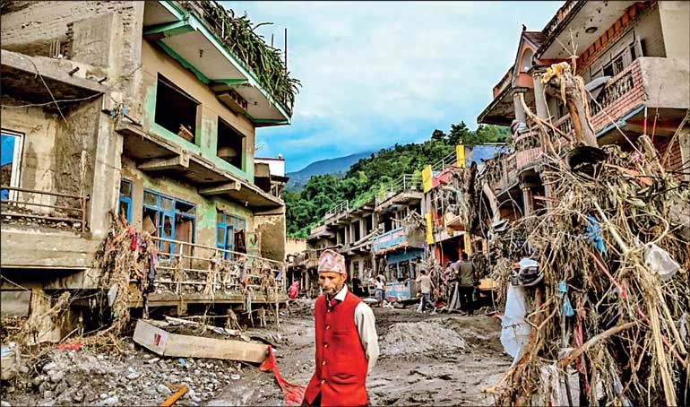
Whether the earthquake triggered the avalanche, or the avalanche itself produced the earthquake-like shaking, is still under investigation. What is not in question is the pattern. According to disaster risk specialists, the Lhende Khola has now flooded twice in 14 months — this time triggered by an ice-rock avalanche from a glacier that blocked the river and released a sudden surge downstream. The same corridor is also economically strategic: a “friendship” bridge linking Gyirong Port to Rasuwa Port, damaged in flooding just last summer, had paused an estimated $ 724 million in annual bilateral trade for roughly six months.
Why this keeps happening
The Himalaya is warming faster than the global average. Research published earlier this year by scientists in Kathmandu found that glaciers across the Hindu Kush Himalaya region are melting at an accelerating rate, with ice-loss rates doubling since 2000. Retreating glaciers leave behind unstable slopes, over-steepened ice, and hundreds of moraine-dammed glacial lakes — “water bombs” that can burst with little or no warning.
The history is grim: the 2013 Chorabari lake outburst in the central Himalayas contributed to more than 6,000 deaths; the 1994 Luggye Tsho outburst in Bhutan killed 21 people and destroyed downstream infrastructure; Sikkim's South Lhonak lake burst in October 2023 with devastating consequences. Nepal itself lost more than 125 people to floods and landslides in September 2024, and around 60 more in the October 2025 monsoon disasters. Wednesday's event was not a glacial lake outburst flood (GLOF) in the classic sense it was an avalanche-triggered river-blockage flood — but it belongs to the same family of cascading mountain hazards: fast, compound, and lethal precisely because they arrive in minutes rather than hours.
Where AI can genuinely help
No technology can stop an avalanche. But the tragedy of events like Wednesday's is that the fatal interval the time between the trigger high in the mountains and the flood wave reaching villages downstream is often 20 minutes to a few hours. That window is exactly where artificial intelligence, coupled with sensors and satellites, earns its keep.
1. Satellite monitoring and machine-learning hazard mapping
Remote, high-altitude terrain makes ground monitoring nearly impossible which is why the field has shifted to space. Researchers now use Landsat and Sentinel time series with random forest classifiers and artificial neural networks to track the growth and instability of glacial lakes over decades, flagging which lakes are becoming dangerous. A 2025 systematic review of GLOF research highlights multi-sensor data fusion, machine-learning risk models, and hydrodynamic flood-propagation simulations as the core of modern risk assessment. The proposed Himalayan Glacial Lake Monitoring Network (HiGLMN) aims to combine in-situ observations, remote sensing and hydrodynamic modelling into exactly this kind of early-warning backbone. Synthetic aperture radar (SAR) sees through cloud and darkness critical in the monsoon — and AI change-detection on SAR imagery can spot slope deformation or sudden lake drainage within hours.
2. Sensor networks with intelligent triggering
The Cirenmaco glacial lake in the central Himalayas a transboundary lake not far from today's disaster zone already has one of the most advanced early warning systems in the region: sensors monitoring lake level, moraine displacement, ice collapse and downstream runoff, transmitting via Beidou and Inmarsat satellites to a data centre that raises alarms for downstream communities. Wireless sensor networks of this kind are cheap relative to engineering works like artificial lake drainage. AI's role is to sit on top of the sensor stream: filtering false alarms, fusing seismic, water-level and weather signals, and deciding — in seconds whether an anomaly is noise or the start of a catastrophe. Wednesday's event began with a detectable seismic signal at 8:37 a.m., and the dammed river impounded water for roughly twenty minutes before breaching; an automated system correlating that signal with river-gauge anomalies on the Lhende Khola could, in principle, have pushed alerts to downstream villages before the surge arrived.
3. AI flood forecasting at river-basin scale
Machine-learning river forecasting has matured rapidly. Google's AI flood forecasting (Flood Hub) now provides riverine flood predictions days in advance across dozens of countries, including South Asia, using LSTM-based hydrological models that work even in poorly gauged basins. Commercial and research systems combine satellite altimetry with AI to produce “virtual gauging stations” for remote Himalayan catchments where no physical gauge exists forecasting river surges minutes to hours ahead. For sudden dam-breach floods, hydrodynamic simulations pre-computed by AI surrogate models can map, in advance, exactly which settlements a breach at any given point would inundate and how many minutes they would have.
4. Last-mile alerting and evacuation intelligence
A warning that does not reach a farmer on a riverbank is worthless. AI helps here too: cell-broadcast targeting of only the at-risk zone (avoiding alert fatigue), multilingual voice alerts for communities with low literacy, and reinforcement-learning-optimised evacuation routing. After the disaster, AI accelerates response the Copernicus activation will likely involve automated damage mapping from satellite imagery, the same technique used to prioritise search-and-rescue after the 2023 Turkey earthquakes.
The honest caveats
AI is not magic. Models trained on historical events struggle with unprecedented compound hazards and this quake-avalanche-flood cascade is exactly the kind of low-frequency, high-impact event that sits in the thin tail of any training distribution. Sensor networks need maintenance budgets that outlast donor funding cycles. Transboundary rivers like the Bhote Koshi demand data-sharing between Nepal and China that politics does not always permit. And false alarms erode trust: an early warning system that cries wolf twice will be ignored the third time.
But the direction is clear. The Lhende Khola has flooded twice in 14 months. The glaciers above it will keep destabilising as the region warms. The choice is not between AI and no AI, it is between a Himalaya monitored intelligently and one that keeps surprising us at 8:37 in the morning.
What Nepal — and the region — should do now
1. Instrument the known choke points. Every river descending from the Nepal–Tibet border with settlements downstream should have telemetered gauges and seismic sensors feeding an AI anomaly-detection layer.
2. Adopt basin-scale AI forecasting. Integrate open systems such as Google Flood Hub and Copernicus-derived products into the National Disaster Risk Reduction and Management Authority's operational workflow.
3. Pre-compute the flood maps. Run AI-accelerated breach simulations for every high-risk lake and landslide-dam scenario, so evacuation zones are known before the event, not after.
4. Invest in the last mile. Sirens, cell broadcast, and community drills convert minutes of warning into lives saved.
5. Formalise Nepal–China data sharing. This flood began in one country and killed in two — with more than 550 missing on the Chinese side alone. The sensors, and the alerts, must cross the border faster than the water does.
The Bhote Koshi disaster will be counted, mourned, and studied. The measure of whether we learned anything will be simple: the next time the mountain moves at 8:37 a.m., will the phones downstream ring at 8:38?
(The author is Visiting Lecturer, Computer and Data Science, York St John University, London, United Kingdom and PhD Researcher in AI and Robotics. He could be reached via email at [email protected])
Sources
Nepal Police bulletins (27 Aug 2026, 5:00 and 8:15 a.m.); OnlineKhabar (27 Aug 2026); CNN live coverage (26–27 Aug 2026); Bloomberg (27 Aug 2026); Nepal PMO statements; Nepal Tourism Board data; statements by Nepal's Foreign Minister Shishir Khanal; Bulletin of the American Meteorological Society — HiGLMN proposal (2025); International Journal of Disaster Risk Reduction — Cirenmaco EWS (2022); Geosciences (MDPI) — GLOF remote-sensing systematic review (2025); ICIMOD glacier research, Kathmandu.