Thursday Sep 24, 2026
Thursday Sep 24, 2026
Saturday, 25 July 2026 01:04 - - {{hitsCtrl.values.hits}}
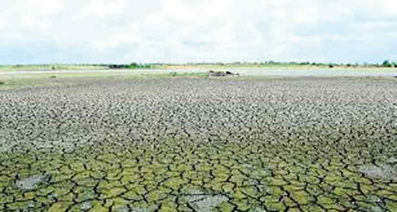
While El Niño dominates global headlines, Sri Lanka's rainfall will ultimately be determined by how several climate systems interact over the Indian Ocean. The coming two months will therefore be critical in determining whether the island experiences a relatively heavy rainy season or one marked by significant water shortages.
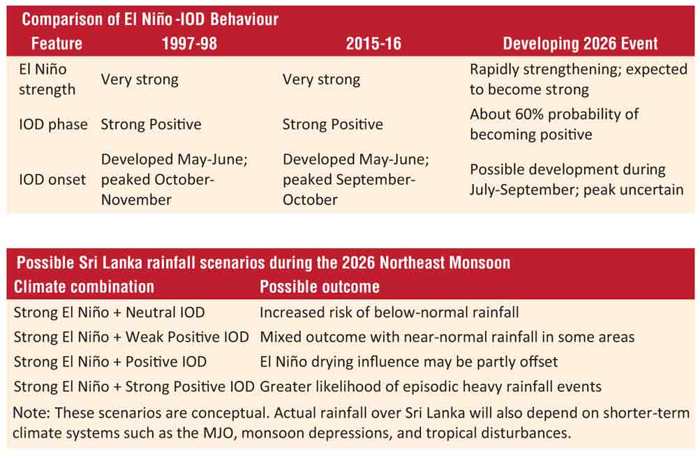
 Recent forecasts from the International Research Institute (IRI) indicate that sea surface temperatures in the Pacific reached about +1.7°C by mid-June 2026, confirming the development of a strong El Niño. The United States Climate Prediction Centre (CPC) has confirmed that El Niño is now well established and is expected to continue strengthening during the coming months., with a 97% probability of persisting into early 2027. The World Meteorological Organisation (WMO) has warned that parts of South Asia could receive below-average monsoon rainfall. At this stage of development, the warming is stronger than observed during the corresponding periods of the powerful 1997 and 2015 El Niño events, two of the strongest on record.
Yet Sri Lanka's recent weather tells a more complex story, raising an important question: Can Indian Ocean climate systems reduce the impact of a strengthening El Niño?
The answer depends on the interaction of several large-scale climate systems. While El Niño provides the broad seasonal background, Sri Lanka's rainfall is also influenced by the Indian Ocean Dipole (IOD), the Madden-Julian Oscillation (MJO), unusually warm surrounding sea surface temperatures, and weather disturbances developing over the Bay of Bengal and the Arabian Sea.
Importance of Indian Ocean Dipole
The Indian Ocean Dipole, which measures the difference in sea surface temperatures between the western and eastern Indian Ocean, appears to be moving towards a positive phase. Current forecasts indicate roughly a 60% probability that a positive IOD will develop towards the last few months of 2026.
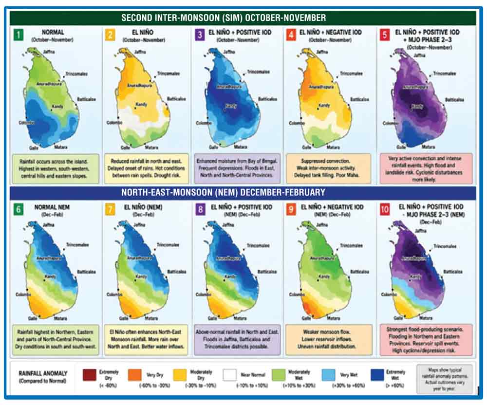
A positive IOD generally produces warmer waters in the western Indian Ocean, encouraging cloud development and increasing the likelihood of rainfall closer to Sri Lanka. This could support rainfall during the Second Inter-Monsoon (October-November) and reduce the risk of widespread drought before the onset of the Northeast Monsoon.
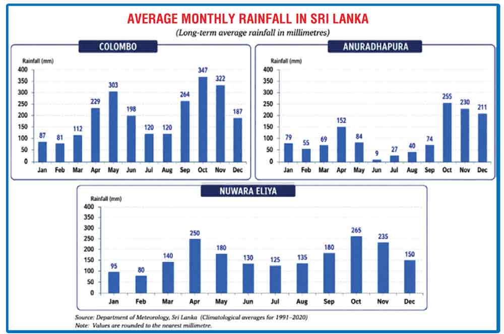
However, a positive IOD does not necessarily mean continuous rainfall. Instead, rainfall may occur as short periods of intense downpours separated by longer dry spells. Such conditions increase the risk of flash floods while still leaving some areas with below-normal seasonal rainfall.
Madden-Julian Oscillation remains weak
The Madden–Julian Oscillation (MJO) behaves differently from El Niño and the IOD. Rather than persisting for several months, it is a moving pulse of enhanced and suppressed tropical cloud formation that travels eastward around the tropics every 30 to 60 days. As it passes through a region, it can temporarily enhance or suppress rainfall, including over Sri Lanka.
At present, the MJO is weak and poorly organised and is therefore unlikely to exert a significant influence on Sri Lanka's weather over the next few months. Nevertheless, the MJO can change rapidly, and its evolution will continue to be monitored as the inter-monsoon season approaches.
Should Sri Lanka be concerned?
Sri Lanka is approaching two important rainy seasons, the Second Inter-Monsoon (October-November) and the Northeast Monsoon (December-February), at a time when several major climate systems are evolving simultaneously.
Of these, the Northeast Monsoon is particularly important because it supplies much of the rainfall received by the Dry Zone.
 The prudent approach is therefore to prepare for both possibilities - drought or floods. Water managers, farmers and policymakers should plan for potentially drier than-normal conditions while remaining alert to the risk of localised flooding and landslides caused by short-lived weather systems and extreme rainfall events
A strong El Niño often reduces Northeast Monsoon rainfall by weakening the transport of moisture from the Bay of Bengal. However, a positive IOD can partly or even fully offset this effect by enhancing the transport of moisture across the Indian Ocean. Consequently, Sri Lanka's seasonal rainfall will depend on the combined influence of El Niño, the IOD, the Madden-Julian Oscillation (MJO), weather disturbances over the Indian Ocean, and the strength of the monsoon circulation, rather than on El Niño alone.
Current forecasts suggest that the MJO is unlikely to play a major role during the coming months because it remains weak and is not expected to become active over the Indian Ocean in next few months.
Lessons from 1997 and 2015
The 1997 event featured one of the strongest positive IOD episodes ever observed, occurring simultaneously with the exceptionally strong 1997-98 El Niño. Together they produced major climate impacts across much of the Indian Ocean region.
Similarly, during 2015, a strong positive IOD developed alongside another very strong El Niño. These two years clearly demonstrate that El Niño does not act in isolation.
Research by the Sri Lanka Department of Meteorology has shown that during the 2015 Second Inter-Monsoon, the combined influence of El Niño, a positive IOD and favourable phases of the MJO helped sustain rainfall despite the presence of a strong El Niño.
In 2026, El Niño is already strengthening rapidly, while forecasts indicate an increasing likelihood of a positive IOD later in the year. The key question is whether the positive IOD will develop early enough and become strong enough to reduce El Niño's drying influence during the Second Inter-Monsoon and the Northeast Monsoon.
If the positive IOD remains weak or develops too late, Sri Lanka could experience below-average Second Inter Monsoon and Northeast Monsoon rainfall, with possible implications for agriculture, irrigation and water resources.
Looking ahead
A developing Super El Niño remains a significant concern for the period from July to September 2026 and again from December 2026 to March 2027.
Overall, the current outlook suggests that the Second Inter-Monsoon (SIM) may prove relatively resilient despite the strengthening El Niño, partly because of the possible development of a positive Indian Ocean Dipole (IOD).
The Northeast Monsoon (NEM), however, is likely to be the season of greatest concern, consistent with Sri Lanka's historical experience during previous strong El Niño events.
The period from August to September 2026 should provide a much clearer indication of how El Niño, the Indian Ocean Dipole and other regional climate drivers are likely to influence Sri Lanka's rainfall during the remainder of the year. Until then, current projections should be regarded as an early warning rather than a certainty.
The prudent approach is therefore to prepare for both possibilities - drought or floods. Water managers, farmers and policymakers should plan for potentially drier than-normal conditions while remaining alert to the risk of localised flooding and landslides caused by short-lived weather systems and extreme rainfall events.
(The author holds a B.Sc. in Agricultural Engineering and an M.Sc. in Soil and Water Management. He served as Subject Matter Specialist in Irrigation, Water Management and later as Director of the Natural Resources Management Centre, Department of Agriculture. He has worked with FAO in Sri Lanka and Bangladesh for several years)