Saturday Aug 01, 2026
Saturday Aug 01, 2026
Tuesday, 2 December 2025 02:25 - - {{hitsCtrl.values.hits}}
Context
Asia and the Pacific is also the global region most prone to disasters. It’s likely this situation will be considerably aggravated by climate change. Four environmental disruptions induced by climate change are of particular concern in Asia and the Pacific: sea-level rise and storm surge, cyclones and typhoons, riparian flooding, and water stress.
The Intergovernmental Panel on Climate Change (IPCC) Fifth Assessment Report highlights South Asia’s vulnerability to climate change, predicting rising temperatures, more variable precipitation, and increasing intensity and frequency of natural hazards.
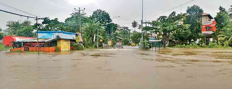
The geographical location of Sri Lanka makes the country prone to several natural hazards, mostly weather - and water-related, such as flooding, landslides, lightning, drought, tsunamis, etc. Sri Lanka’s vulnerability to disasters stems from its high population density and economic activities, which are mainly concentrated in flood-prone and coastal areas.
The country is frequently placed among the top ten countries in the world in terms of vulnerability to climate catastrophes (German Watch, 2019 and 2020). Evidence of changing climate conditions across the island includes rising annual average mean temperatures, rainfall, and drought patterns, among other things, with the dry and intermediate (DandI) zones, considered the island’s agricultural heartland, being more vulnerable to climate change than the rest of the country.
 Asia and the Pacific will be greatly impacted by climate change, partly because of its high exposure to climate impacts and partly because of the great vulnerability of some areas. This warming will be least rapid in Southeast Asia, but stronger in South and East Asia, and stronger in the inner parts of Asia, especially in North Asia. South Asia, East Asia and Southeast Asia will also very likely experience an increase in the occurrence of extreme weather events, such as heat waves and flash floods, as well as a 10–20% increase in tropical cyclone intensities. Sea-level rise should also be greater than average in the region, at about 3 mm/year. (Cruz et al. 2007). Among the impacts of these changes is a possibly significant decrease in cereal production, though there will be regional differences in maize, wheat, and rice yields. A northwards shift of the arable lands is also likely; currently a large share of the region’s arable lands are put to use. Livestock, fisheries, water resources, and food supply could also be significantly reduced. The different socioeconomic impacts of climate change could influence migration patterns in different ways. Climate-related disruptions of human populations and consequent migrations can be expected over the coming decades.
National impact
Due to a combination of heavy rainfall, geological changes in the hill country, and deforestation, the severity of landslides in the country’s mountainous regions has increased over the past two decades. In the districts of Badulla, Nuwara Eliya, Ratnapura, Kegalle, Kalutara, Kandy, and Matale, landslides are prevalent.
According to estimates from multiple models, Sri Lanka’s annual mean temperatures will increase. There will be sea level rise, storm surges, and coastal erosion, with the greatest impact on the west, southwest, and southern coastal regions, where nearly half of Sri Lanka’s population resides. The northern region of the country is frequently struck by cyclones, especially in November and December. In the past, cyclones and other climate-related disasters have been relatively mild, but their frequency and magnitude are likely to increase in the future.
Conventional challenges faced by the irrigation sector in the country get compounded and more complex due to increased risks posed by natural hazards intensified by climate change and other changes.
Under the Disaster Management Act, the National Disaster Management Policy and National Disaster Management Plan shall provide guidance for ‘the protection of life of the community, property, and environment from disasters and the development and maintenance of disaster-resilient infrastructure’, ‘the effective use of resources for preparedness, prevention, response, relief, reconstruction, and rehabilitation,” and ‘pre-disaster planning, preparedness, and mitigation while sustaining and further improving post-disaster relief, recovery, and rehabilitation capacities’.
The Government of Sri Lanka is a signatory to the Sendai Framework for DRR(SFDRR) and the National Disaster Management Plan 2018–23 was developed to align with and aim to realise national SFDRR commitments.
Practical suggestions
Conventional wisdom makes the Government Agent the first responder. Backed by scores of Divisional Secretaries. The Disaster Management Centre has specific functions to perform. In extreme situations a Commissioner General Essential services is appointed.
Practical guides would require essential services to be identified. The entire mechanism needs to be scientifically informed well in time. The NBRO, Met Dept., Hydrology and Disaster Management (Hug and DM) division are some of the sources.
During Elections over 100,000 public officials, buildings, vehicles are commandeered and deputised on duty. Equally we should identify departments, staff categories, locations to service needs during disasters. There is nothing to prevent the nine Governors being deputised by the President to steer the provincial disaster management response mechanism
Sri Lanka is frequently placed among the top ten countries in the world in terms of vulnerability to climate catastrophes (German Watch, 2019 and 2020). Evidence of changing climate conditions across the island includes rising annual average mean temperatures, rainfall, and drought patterns, among other things, with the dry and intermediate (DandI) zones, considered the island’s agricultural heartland, being more vulnerable to climate change than the rest of the country
Providing information to the public is key. In key essential service providers we should ensure families and employees alike are secured to ensure they can provide services uninterrupted.
An example of the functions of a specialised agency
Hydrology and Disaster Management (Hyg and DM) division is a specialised division of the Irrigation Department (ID), which is responsible for collecting and maintaining the hydro-meteorological information system of the country. It was formed as a separate division in the year 1935, around 35 years after the formation of the Irrigation Department. However, the collection of hydro-meteorological data in major river basins had been started a few decades back. The division mainly collects water levels in rivers and streams. In addition, the rainfall is measured in most of the river gauging stations. As well as wind speed, humidity, temperature, and evaporation are also measured in several stations.
Objectives
The primary objectives of the division, which plays a unique role in ID, are:
1. Hydrological Data Collection and Management
2. Hydrological Data analysis
3. Flood Forecasting and Early Warning
4. Coordination with other Disaster Management Authorities for better management of disasters.
Functions
The main functions of the division can be summarised as follows.
1. Collection of hydro-meteorological data throughout the country
2. Archiving, storing, and dissemination of hydro-meteorological data and information. Processed Hydro-meteorological data and information collected and archived by the division are used not only by the ID, but also by other institutions responsible for water-related infrastructure development for various purposes in the country. These data are mainly used for water resources planning and management for irrigation development, domestic and industrial water uses, flood management, academic research work carried out by different professionals and university students, etc.
3. Developing and updating Rating Curves of Hydrological stations around the country (both the permanent and peripheral gauging stations).
4. Processing hydro- meteorological data and converting them to useful information
5. Developing Rating Curves for irrigation canals.
6. Developing flood models for flood early warning and forecasting.
7. Mapping flood events in major river basins.
8. Publishing Hydrological Annual.
9. Monitoring, Forecasting and Issuing flood warnings for major river basins of the country.
Flood early warning
Flood monitoring and issuing early warning messages for all major river basins of the country 24X7-hour basis can be considered as one of the important tasks of the division. These messages are issued to several responsible authorities including Disaster Management Centre (DMC) and the general public in each and every flood event. Historical records bear witness how accurately and quickly those messages are being delivered. These immediate actions which were taken by the division have not only reduced damages to the properties but also to save many human lives. Following graphs verify the accuracy and the quickness of the early warning messages which were issued during most recent floods in 2021.
Preparation of Ratings Curves
Engage in taking discharge measurements can be considered as one of the major key responsibilities of the Division. Discharge Measurements are done not only in Major rivers, but also in tributaries where quantification of water needs to be done. The process of taking discharge measurements is generally known as “current metering”. Developing and updating the Rating Curves are the ultimate purposes of this process.
Hydro-Meteorological Information System (HMIS)
In addition to the 42 permanent gauging stations, there are 106 automated stations which are installed, supervised and maintained under this division. Data is transmitted automatically and Engineers and Technical Staff of the division visit those stations regularly in order to maintain the stations and assure the quality of the data. These stations are installed such that it covers most of the critical and important locations of major river systems of the country. Data is transmitted to the system every 10 minutes. These data play a significant role during flood events and are very useful in running hydrological models for forecasting purposes. However, considering the security and the capacity of the system, access to the system is permitted only for authorised parties. The following figure is an image of the user interface where the data is amalgamated and displayed.
Semi-Automated Information System (SAIS)
As mentioned above, there are 42 permanent gauging stations which collect both river water levels and rainfall hourly. In addition to that some of these stations have been developed into Hydrometric Weather Stations. These stations are manned with HSHH on a 24x7 basis.
(The author is a former member of Commissioner Election Commission and Former Governor Northern Province)

