Tuesday Jul 07, 2026
Tuesday Jul 07, 2026
Friday, 15 March 2024 00:28 - - {{hitsCtrl.values.hits}}
 This narrative is a follow up to the article by the writer titled, ‘Adani wind project in Mannar and ecological threats’ published in the DFT on 06 March 2024 (https://www.ft.lk/columns/Adani-wind-project-in-Mannar-and-ecological-threats/4-759216)The intent is to address specific items covered by the 27 February WNPS hosted Media Conference panelists. Presented below are views - expressed in simple terms - of a person familiar with the wind industry:
1. Why wind project in Mannar - why not alternative sites with lower ecological impact
A panelist suggested Ambawela as a suitable location.
The wind resource map of SL shows locations in the hill country with high average annual wind speeds that indicate resource abundance. Unfortunately, the winds experienced in the hilly regions tend to be turbulent and present a punishing operational environment for a wind turbine (subject to high fatigue loads). The turbine shuts down when the wind speed exceeds the operational limit. Although the high wind speeds raise the average annual value computed at the location, there is no energy benefit gained during periods of high wind speed (turbine not operating).
Modern wind turbines are large in size and capacity and designed to operate at locations that experience low to moderate wind speed regimes. The wind is steady and not impacted by ground topographic features that induce turbulence. The ‘topographically flat’ NW, N and SW regions of SL display this wind characteristic and are ideal for resource harnessing on a large scale.
2. Land coverage and resource benefit from 400MW of wind power in Mannar
Mannar Island is dry and somewhat barren with an area of about 130 square km (approx. 32,000 acres). Now consider the following:
This is a significant amount of vitally needed electricity for SL that is produced with zero price and currency risk exposure that importation of fossil fuels for power generation would entail.
The reader should note that the land occupied by the wind farm can be subject to dual use. Forestry, animal husbandry, agriculture, process industries, etc. can take place within the land spread of the wind farm.
3. Tariff for foreign investor operated project above the market price
The panelist who discussed the tariff quoted confusing figures. However, it is not relevant to quote the low wind energy tariffs seen in the US and India and expect the same in SL. Factors such as project size (economics of scale), industry maturity, availability of skilled labor, transport equipment and cranes are elements that influence the project cost.
The situation in SL is different. The industry footprint is limited and much of the transport and installation equipment and skilled labor must come from abroad.
Additionally, the cost of capital will be higher in SL due to country risk perceptions of the lenders. Thus, the tariff required to make the project financially viable will be higher.
It would have been advantageous for SL if bids were solicited from developers for the Mannar Phase II wind project based on a feed in tariff or if the development opportunity was subjected to a tariff auction. This is an established practice in India. A government negotiated tariff with a single party will not yield an optimal benefit.
4. Avian collision risk assessment modelling
The EIA report carried out on the 250MW Mannar Phase II project is extensive. The assessment of avian impact due to collision and habitat disturbance is an exceedingly complex matter to analyze and the results presented will inevitably lead to expressions of dissent.
The avian expert on the panel claimed that the collision risk assessment modelling was not robust, and the EIA avian impact study did not utilize advanced tracking data.
The expert had conducted GPS tracking of sample bird types that showed them flying over the zone where the wind turbines are to be located. How should one use the bird tracking data that result in traces on a map to determine collision risk?
The EIA report states: “Birds flying through the turbine rotor swept zone are potentially at risk of collision and serious injury or death”.
Allow me to describe the challenge faced.
The wind turbines on the Mannar Phase II project will be located hundreds of meters apart. Each turbine features a 150m diameter three bladed rotor with the axis of rotation at 140m height. Assume that the rotor spins at 20 RPM (Note: Although the rotational speed is low, the blade tip speed is high and avian impact will result in injury or death).
Assume a bird flight path intersecting the area swept by the rotor blades. At a rotor speed of 20 RPM, each blade will meet the projected point of bird collision every 3 secs. Since there are 3 blades, the bird impact possibility will occur every second.
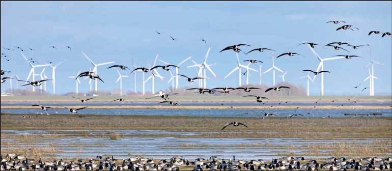
The swept area of the 150m diameter rotor is 17,678 sq. m. Assume 5% of this area (very generous) is occupied by the blades. If a bird flies through the rotor at 10m/sec (assumed), one could conclude that it has a high probability of avoiding a collision. Thus, the probability of blade collisions involving endemic birds that fly over the wind farm featuring turbines installed hundreds of meters apart should be extremely low. Unfortunately, raptors that hover over the wind farm area seeking prey tend to use the wind wake from the rotor blades to gain lift and they are more vulnerable to collision (flirting with the rotor).
A panelist claimed that the wind turbines represent a barrier that birds must navigate through and there is a petition presented on the Internet that calls for stopping the Adani Mannar Wind Project because it blocks the international migratory bird corridor.
I do not believe in the barrier theory. There are numerous photos on the Internet that show flocks of migratory birds flying over wind farms. The so-called barriers will not stop avians if the food chain at the zones they are heading to is not degraded and there are areas for nesting.
5. Concerns expressed about flood impact
The writer fails to understand how a wind farm that features scattered structures occupying an area of approximately 30×30m at ground level and spaced hundreds of meters apart can affect the flood characteristics in the ‘topographically flat’ terrain of Mannar.
6. Concerns about significant excavations
The 100MW Mannar Phase I wind project with 30 large capacity wind turbines were secured on foundations that featured several concrete piles and a ground level slab that supported the turbine. The slab may occupy an area on the surface not exceeding 900 sq m.
Since the Phase I project is commercially operating today, the writer assumes that this construction activity was reviewed and approved by the Geological Survey and Mining Bureau.
If this was the case, gaining approval for the Phase II project would be a mere formality.
Concluding remarks:
Fauna and flora is our national heritage while power and energy is essential for our wellbeing.
Today, with energy options influenced by risks associated with cost of external supply and the desire to harness renewable energy, the Mannar island wind resources offer a low hanging fruit. Considering the curtailment of wind project development on Mannar island due to avian concerns is a call that should be made by the stakeholder State institutions. Their decision should be based on the opportunities and risks involved.
Siting wind farms close to wetlands is not unique to Mannar. There are numerous wind projects operating in the world that must cope with avian issues. Modern wind farms sited close to wetlands ensure that turbines are set away from bird nesting areas. Collection of field data at operational projects and use of technology to further mitigate avian impact is the way forward.
This is not a black or white scenario. A progressing society must act in a rational and scientific manner to resolve complex, conflict prone issues that deliver optimal benefit to the nation.
(The author is a renewable energy specialist and could be reached via email at [email protected])

