Wednesday Jun 03, 2026
Wednesday Jun 03, 2026
Friday, 13 May 2016 00:00 - - {{hitsCtrl.values.hits}}
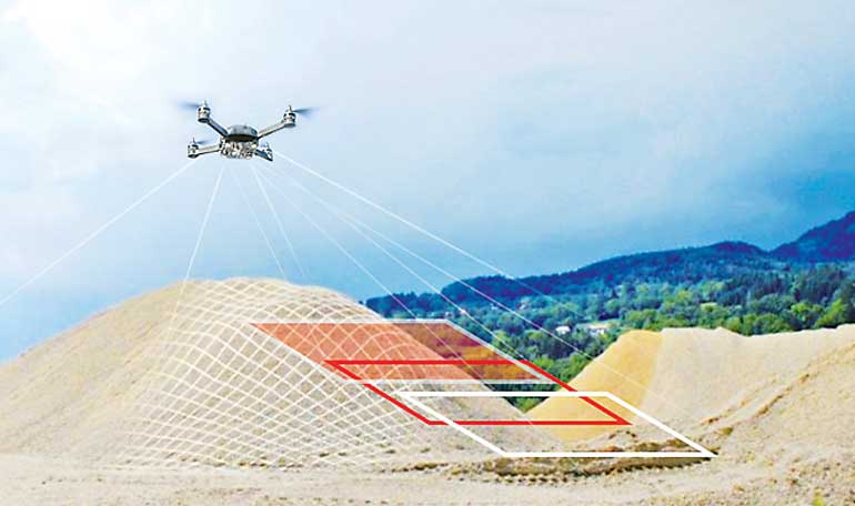
Bentley Systems Incorporated, a leading global provider of comprehensive software solutions for advancing infrastructure, together with their Sri Lanka Partner Geoinformatics International Ltd., announced General Access to its new ContextCapture offering. ContextCapture is Bentley’s first product release of the Acute3D software technology it acquired. The software is ideally suited for any organisation that could apply 3D models of real-world context to benefit infrastructure design, construction, or operations.
‘Context Capture’ is a dedicated research results of two senior researchers Jean-Philip Pons and Renaurd Kevin from two major research institutes, École des Ponts ParisTech and Centre Scientifique et Technique du Bâtiment developed a software solution for automatic high resolution 3D reconstruction from Photographs, based on the highest-performance photogrammetry, computer vision and computational geometry algorithms. It won the French’s ‘most innovative startup’ award.
With ContextCapture, users can easily produce high resolution 3D models of existing conditions using photos taken with any digital camera. The software generates a detailed reality mesh incorporating the referenced photography. This results in a navigable 3D model with fine and photo realistic detail, sharp edges, and precise geometric accuracy. These highly detailed models can be of virtually any size or resolution, up to city scale, and created much more quickly than with other technologies.
Bentley also announced General Access to ContextCapture Center for ‘grid computing’ power to dramatically expedite processing time for very large models (typically involving more than 30 gigapixels of imagery).
Taking Acute3D technology to the next level, Bentley’s new ContextCapture offers significant new advantages to users, including:
n A new multi-platform browser plug-in and desktop viewer that supports multi-touch and allows users to easily and consistently share reality meshes on desktop and mobile devices, even for models of entire cities;
n Enhanced level-of-detail generation and adaptive tiling, including tools for surface and volume measurement;
n Directly providing context for engineering and geospatial workflows, including native support within microstation connect edition;
Bentley Systems Director of Business Development Pascal Martinez said, “ContextCapture offers a new and versatile way of capturing reality to serve as context for design, monitoring, inspection, and surveying processes, complementing Bentley Pointools and Bentley Descartes. I’m pleased to say that reality meshes produced by ContextCapture can now be intrinsically integrated throughout Bentley’s common modelling environment, by way of native support within MicroStation CONNECT Edition.”
AEROmetrex Technical Director David Byrne said, “With ContextCapture, we’re able to automatically construct highly detailed 3D models of virtually any size for our clients, faster and at much less cost than with traditional methods. But what’s most powerful is the amazing context that it provides to facilitate better decisions throughout design, construction, and operations. ContextCapture allows you to create a fully photo-textured, geographically located 3D model, all derived directly from digital photography. And, once the models have been built, they can be quickly and easily viewed on any desktop or mobile device. We think ContextCapture is going to revolutionise the geospatial industry.”
ContextCapture, and digital photography including from UAVs, can provide any infrastructure professional with: Unrivalled 3d mesh creation and optimisation from ordinary photographs, with high-quality texture mapping and optimal aero triangulation accuracy;
High performance, through multi-core support and optimisation for use with general purpose graphics processing units;
Extensive scalability through sophisticated tiling mechanisms and ‘grid computing’ support;
Robust and flexible publishing capabilities to produce and publish 3d visualisation-ready models through a variety of formats and viewer applications with the required level-of-detail – in a way that maintains the highest quality but minimises hardware requirements.
Geoinformatics Managing Director Sudarman Siripala said, good data can lower the cost of borrowing money. The IMF has found that, if emerging market and developing countries invest in better quality data, they can reduce the cost of borrowing by an average of 20%. We are ready with the software and UAV to support any infrastructure projects and train the users for Context Capture applications in Sri Lanka.


