Saturday Feb 14, 2026
Saturday Feb 14, 2026
Saturday, 12 August 2017 00:01 - - {{hitsCtrl.values.hits}}
The beauty of Sri Lanka is well known throughout the world. In addition to the natural beauty, the country boasts of ancient treasures – magnificent stupas, rock temples with well-carved murals, royal palaces and man-made tanks. Even during 400+ years of domination by European powers, many are the leftovers to be admired.
Apart from the tourists who are attracted by so many places to visit, Sri Lankans themselves find it so exciting to travel around and enjoy the splendour and grandeur of our beautiful island. Interesting places to visit have regularly been made known through stamps using colourful pictures.
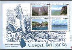
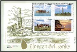
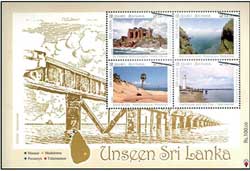
A recent issue of a dozen stamps with the title ‘Unseen Sri Lanka’ paves the way to identify places which are well worth a visit. Not that these places have not been visited by many but there can be others who have missed them and could be prompted to do an adventurous trip. From the stamp collectors’ point of view, of course, these are ‘musts’ for their albums.
Four attractive Souvenir Sheets in addition to the First day Covers enhance the value of these stamps.
Let’s make it an enjoyable outing!
 Of at least the dozen tall waterfalls in the country, the highest – 263 metres – is the Bambara-kanda Falls. It can be reached by going along route A4 and turning left from Kaluphana junction in Belihul Oya. Also known as Bambarakele Falls, there are three drops and the most spectacular view is when it is fed by monsoon rains.
On the A25 road from Siyambalanduwa to Ampara is Govinda Hela, popularly known as Westminster Abbey, a towering square peak. It is believed to be a fortress dating back to the days of the Yapahuwa Kingdom (13th century). A number of caves and ruins of abodes of monks scattered over a large area can be seen on the northern slope of the rock. Two moonstones – one with carvings and the other without – have been found on a flat area of over five acres at the summit of the rock.
Driving from Matara towards Tangalla about four miles from Dikwella, if you hear a ‘hoo’ sound from the sea coast you are close to the Hummanaya – a blowhole reputed as the second largest of only a half dozen known in the world. The water spouts as high as 60 feet (18 metres) into the air especially in June when the southwest monsoon is the worst. Water is trapped in a fissure in a sea level cave, then forced by wave pressure 75 feet (23 metres) straight up through a chimney in a flat rock, is how the action has been described. Hummanaya is situated about 2 km turning off at Kudawella junction.
Senanayake Samudra is the main reservoir of the Gal Oya Valley, the site of the Sri Lanka’s first major post-independence irrigation project initiated by first Prime Minister/Minister of Agriculture & Lands, D S Senanayake. It was an attempt to achieve self-sufficiency in rice and other foodstuffs. Situated at Inginiyagala in the East Coast, the tank has a capacity of collecting 770,000 acre feet (cubic meter 9.5 x 10⁸) of water. Its catchment area is 384 square miles. Water is distributed by it for cultivation of over 110,000 acres of land. The extent of water is 91 square kilometres.
 Dating back to the Portuguese times Hammen Hill Fort was built in a small island surrounded by Kytes and Karativu islands in the Jaffna peninsula by the Portuguese in the middle of the 17th century. Named by the Portuguese as Fortalega Real (Fort Royal), it was re-built by the Dutch in 1680 and named as Hammenheil (Heal of Ham). Today, it has been converted to a tourist hotel.
Delft Island – also called Neduntivu – is the outermost and second largest of the Jaffna islands. Named after the Dutch city Delft by Rijckloff van Goens, the Dutch Governor in Ceylon in the 1660s. About 20 square miles (52 sq. metres) in size with a population of about 10,000, Delft is known for the wild ponies seen roaming about. The animals, now diminshed to about 450, are said to be of a breeding stock from Portuguese times.
Also in Alamanawam in the Delft Island is the Queen’s Tower considered to be a lighthouse tower built by the Dutch. It is over 50 feet in height and constructed in a square shape consisting of five floors which become smaller as it goes high. There is an arch-shaped gate towards north-south in the lower part. Blocks of cut lime stones have been used for its construction.
Kudiramalai Point – also known as Thambapanni – is a historically significant ancient sea port which lies in the western coast at the end of the Wilpattu National Park in the upper boundary of Puttalam district about 200 km. away from Colombo. Some consider it to be the site where Prince Vijaya and his retinue landed. Pottery fragments, bricks and other remnants found here confirm that this area had been a human settlement since around the Mesolithic period.
 Doric Bungalow, also known as Frederick North Bungalow, in Arippu East – Mannar got its name due to the architectural design of the columns which was similar to the Ancient Greek Doric order style. North, first British Governor in Ceylon (1798-1805) had wanted the bungalow for him to stay when he went to Mannar to revive and supervise the pearl fisheries which was a profitable business for the Government. The two-storey building was constructed using bricks and mortar with the exterior walls decorated with chunam made from lime of burnt oyster shells to appear like marble. All doors and windows are built with arches. Due to being exposed to extreme weather and lack of maintenance, though declared a protected archaeological monument, it is now in ruins.
We are familiar with World’s End in Horton Plains generally accepted as the finest view in all of Sri Lanka. Here the stamp shows the Mini World’s End at Madulsima, a distance of about 180km. from Colombo off Passara in the Badulla District. The place can be reached along the Pitamaruwa Road – ‘Pitamaruwa’ having got the name because it was the place in the pre-railway days when tea boxes were exchanged from one set of caravans to another to be brought down to Colombo to be exported. The Madulsima World’s End is located at the end of the lush Roeberry tea estate. The visitor can view a vast plain starting at the bottom of the mountain and ending towards the East coast. It is 1257 feet deep. Uma Oya and Bambarabotuwa and Kekunagala waterfalls can be seen from the summit.
Sand dunes of Pooneryn are well known among several areas in the north noted for vast stretches covered by sand. The Portuguese had built a fort in the Pooneryn area to protect its possessions in Jaffna. It was later taken over and expanded by the Dutch as a square-shaped with two bastions at opposite corners; the rampart on each of the sides was about 30 metres, it was garrisoned until the late 18th century. The British built a rest house in 1805. In recent times, during the North East conflict, Pooneryn became a strategically important place and there were hard-fought battles between the Army and LTTE. Since 1983 it was garrisoned by the Sri Lankan Army until their withdrawal in 1991. The fort was recaptured by the army in 2009.
Talaimannar lighthouse and old jetty with over a century-old history can be reached by arriving at the Mannar town on A 14 road from Colombo via Medawachchiya and from there along Mannar – Talaimnannar road for 28 km., then turning left 1.5 km. to reach the beach. Today, twelve iron pillars of the jetty which is built in a north – south direction to the sea from the land can be seen. The jetty is built on two parallel pillars and the circumference of a pillar is about 1.5 m. and height about 2.2. m. The space between two pillars is 5.8 m. and the width of the jetty is 7.8 m. Most of the jetty parts are corroded due to sea water and wind.