Sunday Feb 15, 2026
Sunday Feb 15, 2026
Monday, 16 December 2019 00:00 - - {{hitsCtrl.values.hits}}

It was December 1974 and the Hajj was in full swing. The Hajj has been called the greatest pilgrimage movement in the world, with millions of devout Muslims travelling to Mecca every year. It is a requirement for every Muslim to accomplish the Hajj at least once in their lifetime.
This has been a lucrative business for airlines, with chartered aircraft from all over the world helping pilgrims to make the long journey. Martinair (a charter subsidiary of KLM Royal Dutch Airlines) was operating this flight on behalf of Garuda, Indonesia’s national carrier.
The timing of the Hajj is based on the Islamic lunar calendar, so it varies from year to year on the Gregorian calendar, which is used by much of the world. In 1974 it fell in the cooler winter months, and the Dutch aircraft was on its way from Surabaya in Indonesia to Jeddah in Saudi Arabia. With a full load of pilgrims, the flight needed to refuel at an intermediate point, and Colombo’s Katunayake airport was a convenient stopover.

The facts
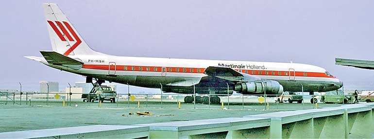
The ill-fated Douglas DC-8-55F aircraft registered as PH-MBH and operating as Martinair Flight 138, was approaching the island of Sri Lanka from the east. There were 191 passengers and crew on board. The pilots first contacted Colombo’s Air Traffic Control at 1616 hours GMT (local time 9.46 p.m) to report they were 130 nautical miles from the airfield.
It was a clear night, the weather at Katunayake airport was reported as good with light winds, visibility in excess of 10 kilometres, and some scattered clouds to the east of the airfield. Aviation navigation facilities in Sri Lanka were still rather basic at the time, and Air Traffic Control (ATC) did not have radar equipment that would allow them to ‘see’ the aircraft. The main navigation beacon, the Katunayake VOR (Very High Frequency Omni-Directional Range), was on test status only. Instead, the pilots were relying on a Doppler system (more on that later) for navigation, although they may well have visually seen the eastern coastline at this time.
The timing of the Hajj is based on the Islamic lunar calendar, so it varies from year to year on the Gregorian calendar, which is used by much of the world. In 1974 it fell in the cooler winter months, and the Dutch aircraft was on its way from Surabaya in Indonesia to Jeddah in Saudi Arabia. With a full load of pilgrims, the flight needed to refuel at an intermediate point, and Colombo’s Katunayake airport was a convenient stopover.
As the aircraft approached the centre of the island, the pilots were switched to Approach Control, and at 1638 hours GMT reported they were descending to 6,000 feet and were 14 miles from the airfield. The controller (who did not have radar at the time) had no way of verifying this and must have assumed the position was accurate. He cleared the aircraft for further descent to 2,000 feet and asked the pilots to report the “(air)field in sight”.
No further communication with Martinair 138 was received. The sound of an explosion was reported near Maskeliya shortly afterward. Later, eyewitnesses reported seeing an aircraft flying “lower than normal” over Castlereigh and Agrapatana.
Subsequently, it was found that the aircraft has impacted the ground near the fifth mountain of the ‘Anjimalai’ range (also known as the Seven Virgins, or Saptha Kanya) near Maskeliya.
The accident site
The site of the accident was in an area largely regarded as inaccessible. Teams from the Sri Lanka Army and local volunteers struggled to reach the site through thick jungle and granite mountains. Five large hills ranging in height from 4,640 ft to 5,160 ft were in close proximity.
 |
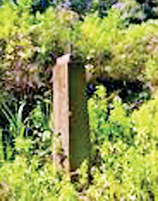
Memorial plaque near the fifth mountain of the ‘Anjimalai’ range (also known as the Seven Virgins, or Saptha Kanya) near Maskeliya. The only marker of the site of what was, at the time, one of the world’s worst airline crashes |
 |
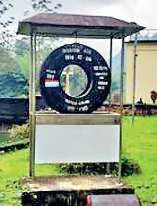
Memorial at Norton Bridge, the closest town to the crash site |
The aircraft had impacted this area resulting in the destruction of the fuselage and wings. Ruptured fuel tanks had started a fire in the vicinity, and the wreckage was scattered over an area of four square miles. The search parties, who took several days to scour the area, eventually found a scene of utter devastation. Even the flight recorders (inaccurately known as ‘black boxes’ even though they are encased in Day-Glo Orange containers to facilitate location at a crash scene) were completely destroyed by the impact. There were no survivors.
The remains of the victims were buried locally with appropriate funeral rites being conducted. The jungle that thrives in this part of the island soon engulfed the surrounding area. Today, a lonely memorial plaque, almost totally overgrown is the only marker of the site of what was, at the time, one of the world’s worst airline crashes.
Norton Bridge, the closest town to the crash site, also has a memorial: one of the tyres of the DC-8 mounted on a pedestal outside the Police Station. The text reads: “Martin Air 1974-12-04 killed 191, 10:10 pm crashed on virgin hills. Dutch Airline Holland” with a painted flag that appears to be that of the Netherlands.
Almost forgotten today, the Martinair accident was a much talked-about occurrence in Sri Lanka at the time. Moreover, it was especially traumatic in what was then a relatively peaceful country, barely in touch with the outside world.
The investigation and report
The investigation was carried out by the Civil Aviation Department of Sri Lanka with assistance from the Dutch and Indonesian authorities.
The captain of the aircraft, Hendrik Lamme, was a 58-year-old Dutchman with over 26,000 flying hours to his credit, of which 4,000 were on the DC-8 type of aircraft. His co-pilot, Robert Blomsa, was 33 years old and also a Dutch national. Captain Lamme had flown to Colombo previously, but his co-pilot was not familiar with the region. No details are available of the third crewmember who must have been on the flight deck that night.
The aircraft had been manufactured in 1966 and acquired Dutch registration in 1973. It was determined to be serviceable at the time of departure on its last flight.
At the time there was no ‘Distance Measuring Equipment’ (DME) available at any radio facility in Sri Lanka. ATC did not have radar either, which would have displayed the position of the aircraft to controllers.
The airplane was equipped with a Doppler system that the crew must have been relying on for determining distance to the airport. KLM used company-standard Doppler systems made by the Marconi. However, due to the aircraft having been procured from another operator, a Bendix unit was fitted in PH-MBH. The displays of the two systems were not compatible and the investigation determined that an error in determining the distance from Katunayake led to an early descent, which caused the aircraft to crash into the mountains.
The conclusion of the investigation was that the accident was a result of Controlled Flight into Terrain (CFIT) whereby a serviceable aircraft impacted rising ground due to confusion as to its actual position.
Pix by Paul Mayes