Thursday Apr 30, 2026
Thursday Apr 30, 2026
Saturday, 10 December 2016 02:05 - - {{hitsCtrl.values.hits}}
The Philatelic Bureau deserves to be complimented for the effort made in looking out for innovative themes. The latest theme selected for a set of 12 stamps is titled ‘Unseen Sri Lanka’ depicting places from different parts of the country which many may have missed visiting.
As mentioned in a recent Stamp Talk column, stamps are a very effective communications tool to promote tourism. The ‘Unseen Sri Lanka’ is yet another commendable effort to promote tourism both locally and globally.
Bambarakanda Falls, also called Bambarakele Falls, is the highest waterfall in Sri Lanka boasting a height of 263m (863 ft). In world ranking it is the 299th tallest. The flow of water is the best after the monsoons. Situated in Kalupahana in the Badulla District it is 5km away from the A4 Highway and is close to Haputale. The waterfall is formed by Kuda Oya, a branch of the Walawe Ganga, the seventh (138km) among the longest rivers in the country.
‘Sir Frederick North Bungalow’ in Mannar has been named after the first British Governor (1798-1805 AC) after Ceylon was made a Crown Colony in the British Empire. Pearl fishing being a profitable export industry he used to travel to Mannar to supervise operations and he had stayed in this bungalow. Built in the tradition of classical Roman architecture with tall columns, only remnants can be seen today. While a flight of steps leading to an upper floor indicates that it was a two-storey building, remains of a few arches over doors and windows are proof of the Greek tradition of architecture. The site can be reached by going along Silwathura road for about 12km from Murunkan junction on the A14 road and a further 2.5km on the Silwathura-Arippu road.
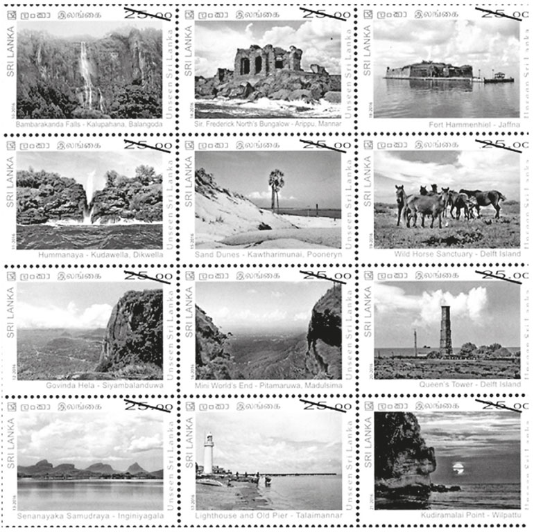
Fort Hammeniel is in a small island between the islands of Kayts and Karativu in the Jaffna Peninsula. It dates back to the days when the Portuguese occupied the country in the 16th century. It was named Fortalega Real (Fort Royal) until the Dutch took it over in 1680, rebuilt it and named it Hammenheil (Heel of the Ham) which was retained by the British and thereafter. It had been used as a store of gunpowder in nine large dungeons and later as a prison. It was under the Sri Lanka Navy and after the end of the war in the North has set up a hotel for tourists.
Hummanaya in South Sri Lanka is the only known blowhole in the country and is the second largest in the world. The name has been derived by the noise ‘hoo’ it creates to be heard from far away. A blowhole is caused when sea water rushes through a submerged cavern and is pushed upwards. The sea water flows underneath the shore, and then comes out of this hole due to pressure. The water fountain created by the geological feature shoots up every couple of minutes and depending on the nature of the sea the spray reaches anything from 25m (82ft) to 30m (98ft). Hummanaya is situated about two km turning off at Kudawella junction from a distance of about 180 km. on A 2 road.
Sand dunes of Poonerin is a popular site in North Sri Lanka. A dune has been described as a hill of loose sand built by wind or the flow of water. Dunes are of different shapes and sizes and most of them are longer in the windward size where the sand is pushed up and have a shorter ‘slip face’ in the lee of the wind. Sand dunes featured in the stamp can be seen by travelling towards Kawtahrimunai from Poonerin in the Poonerin Peninsula.
Wild horses in Delft Island in the North are believed to have descended from the time of the Portuguese. The island (Neduntive in Tamil), home to about 450 wild horses, has been named after the Dutch city of Delft by Rijckloff van Goens, Dutch Governor (1660-63) who had named eight islands after Dutch cities. Roughly oval-shaped Delft Island covers an area of about 50km with its length being 8km and maximum width about 6km.
Govinda Hela (Westminster Abbey) is along the Siyambalanduwa-Ampara road (A 25). Dating back to the 13th century when there was a ruler at Yapahuwa after Polonnaruwa was abandoned following Magha’s rule, it was a rock fortress. It got the name Westminster Abbey during the time of the British because it resembles the famous church in London. Several caves and other buildings have been unearthed on the northern slope where early Brahmin inscriptions have also been found. These indicate that monks had resided in the area. Two moonstones – one with  beautiful carvings and the other without carvings – can be views in a flat land of over five acres on the summit of the rock.
Mini World’s End is located at Madulsima close to Passara town. With a depth of 1257 feet it is only second to the well-known World’s End at Horton Plains. Uma Oya and two waterfalls – Bambarakotuwa and Kekunagala – can be seen from the summit. Situated about 180km from Colombo, Minis World’s End can be reached by travelling along Pitamaruwa road off Passara town.
Queen’s Tower is a square-shaped tower in Delft Island built by the Dutch obviously for the guidance of ships. Over 50 feet in height, it has been built using cut lime stones. It has five floors which become smaller in size as it goes up. The entrance is through an arch-shaped gate.
Senanayake Samudra named after Sri Lanka’s first Prime Minister D.S. Senanayake in recognition of his untiring efforts in taking the country towards self-sufficiency, is one of the largest and most iconic reservoirs in the country. Also called the Gal Oya Reservoir, its water is used primarily for irrigation in the Uva and Eastern Provinces, in addition to powering a small hydroelectric power station. It took four years to build the dam and the reservoir starting in August 1949.With a capacity for collecting 770,000 acre feet (950,000,000m) of water, its catchment area is 384 square miles. The water distributed for cultivation covers over 110,000 acres of land.
Talaimannar Lighthouse near the old jetty built in 1915, is situated in the Old Pier village and can be reached on the A 14 Colombo-Mannar road via Medawachchiya and then along Mannar-Talaimannar road for 28km. Remnants of the jetty which is over 100 years old can be seen including 12 iron pillars. The circumference of a pillar is about 1.5 m. and the height about 2.2. m. The space between two pillars is 5.8 m. and the width of the jetty is 7.8 m.
Kudiramalai Point, the northern most point in the Puttalam District, refers to an ancient port of the west coast of Sri Lanka. It is the west end of the Vilpattu National Park. Findings in the area including fragments of pottery and bricks confirm that the area had been a human settlement around the Mesolithic period. One theory is that it is the place where Vijaya and his retinue landed.

