Thursday Jun 25, 2026
Thursday Jun 25, 2026
Thursday, 3 May 2018 00:00 - - {{hitsCtrl.values.hits}}
Background
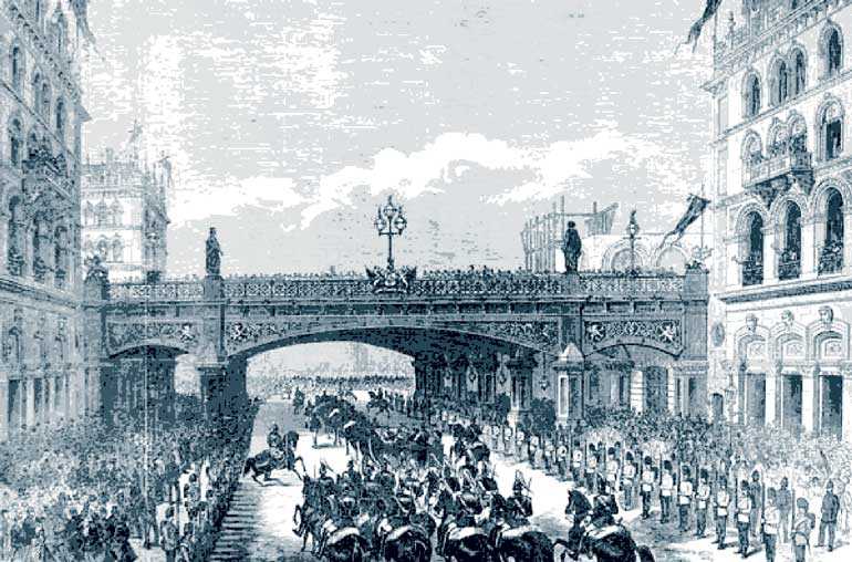
Flyovers are an unavoidable construction architectures in road construction. This had been invented by the British. Holborn Viaduct was the world’s first flyover, connecting Holborn City with Newgate Street, avoiding a deep dip in the road. It was built across the Fleet Valley to get rid of the steep Holborn and Snow Hills. It was built between 1863 and 1869 and opened by Queen Victoria in 1869. Fly pass, viaduct and sky bridge are other names for the same flyovers around the world. There are many kinds of flyovers around the world which serve different purposes. The most recent is the sky mall concept. The malls can be accessed by the flyovers. That has many advantages to reduce the traffic congestion and other environmental externalities.
There are two main reasons for flyover construction to support the traffic congestion management. Those are: clearing a point congestion; clearing an access route congestion; or hybridising of the both requirement. Engineers usually plan for both requirements though the capital expenditure is higher for a hybrid construction, because it is more economical than constructing two flyovers, or altering and spending at two stages.
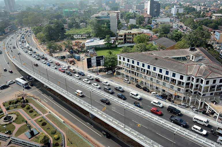
Rajagiriya flyover
The impact of the flyover construction to curb traffic congestion problem has been assessed in terms of traffic decongestion, time savings and fuel savings. It was found that about 35% of the total traffic is diverted to the flyover, which results in a reduction of about 32% in total emission generation. Traveling on the flyover is a time saving technique. The loss of fuel for combustion and the associated cost resulting from waiting for the signal to change are also estimated, and these are found to be significant.
Description of Rajagiriya flyover
The Rajagiriya flyover is a controversial topic in common forums, where the main question is whether it serves the required or designed purposes. There are many answers from different forums but professionals on the subject give different views. The purpose of this article is to discuss some of the views that have been received, and the author is open to more views and constructive criticisms in order to carry out future improvements in projects.
Mainly the design of the flyover is hybrid, i.e., to create an uninterrupted traffic flow on the Bambalapitiya-Kaduwela access route, and to free the Borella-Nawala traffic diversion. Due to the present design, it has eased off only the Borella-Nawala traffic flow, and very minimally eased the Bambalapitiya-Kaduwela traffic flow which should be the prime purpose. If the purpose is Kaduwela–Bambalapitiya access, there are other two points to be considered, i.e., Kanattha junction and the Devi Balika junction, because flyover traffic flow blocks at these two points. Therefore, it is necessary to clear these two points in the same manner. Furthermore, a small mistake was made at the Rajagiriya point, namely, not constructing the merging lanes as necessary for both sides of the flyover, which creates the highest congestion in the peak hour. This same mistake is present in the other two flyovers at Nugegoda and Dehiwala, which obstructs the purpose of the flyover.
Land use theories and social imprint are valuable parameters to keep in mind when designing this kind of land transportation project. Designers must be conversant with land use patterns and the behaviour of the people around the project, apart from the distant road users. Many condominiums are coming up, and many housing projects are emerging in the northern portion of Rajagiriya Township and suburb. Also, all the byroads in the north of Rajagiriya are widening and interconnecting with low-level roads (Colombo-Avissawella), which is the reason for the higher volume of traffic flow towards the eastern end of the flyover. Therefore, land use pattern of the population around Rajagiriya area too is a valuable parameter which has not been considered seriously, and which is one of the critical reasons to the congestion of the Eastern end of the flyover.
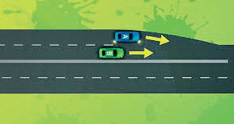
The flyover is four-way, with two distant lanes to either side so as to have constant and uninterrupted flow on the Kaduwela-Bambalapitiya access road, but traffic from four merging lanes to the eastern end of the flyover and four merging lanes to the western end has not been implemented in a professional way considering the traffic impact analysis model. This has created the biggest complication to the project. Basically, the length of 500 m merging access lane is constructed to merge with a vehicle which is arriving at a speed of 60 km/hr. for an uninterrupted merging with the distant lane. At Rajagiriya point it has to be at least a 200 m merging lane to cover an uninterrupted flow of the distant lane with a vehicle approaching at a speed of 20 km/hr. Geographically, both eastern and western end have the feasibility of constructing a 200m access/merging lane, which can remedy 60% of the present problem.
Segregating of bus lanes is a good option for quicker passenger transportation and prioritising the commuters. But segregating one lane from a two lane road is not a viable option for a bus lane. The road was originally a congested road with extremely high traffic. Therefore, the plan died at birth, but the marking is still visible and buses haphazardly use the lane. This block has a high bottle-necking effect on the western end of the flyover. Therefore, it is necessary to readjust the bus lane, by widening only the feasible 200m stretch. This will cure another 10% of the point congestion problem.
The next factor is that bus terminals are blocking the smooth traffic flow of the distant lane. Bus terminals are designated in the middle of the distant lane, which blocks the uninterrupted flow of the traffic, creating high congestion and fatalities and violating a fundamental principle. This basic violation appears in almost all roads in the country. Bus terminals in Senanayaka junction, Devi Balika junction in the west end and in the east end HSBC junction are reducing the continuous traffic flow from the flyover. The terminals should be placed further away – similar to the placement of the Castle Street Hospital bus terminal, for example – from the distant lane, and especially should be constructed after the merging lane, which will have a greatly positive effect to the smooth flow of traffic.
Sky Mall concept
The Sky Mall concept places two malls on either side of the flyover, which can be accessed from the main road at the ground level. This malls can be accessed by constructing two 20m access roads to the malls via the flyover at the second level of the buildings, which would be an innovative concept in Rajagiriya town ship that could make the city iconic. Further, it could be developed into a mall city by integrating more sky malls and further to upcoming condominiums, which reduces the ground traffic and clears the road for long distance flow. This is a common application in many parts of the world.
Conclusion
Overall, the Rajagiriya Flyover design violates critical land transportation principles, and damages the professionalism of the planners and as well as the credibility of the politicians, because it does not serve the purpose for which it was made. It is felt by analysing the design that the designers sacrificed the professionalism to the political vision of the politicians, who just wanted to give a product to the nation. However, this kind of megaproject, which involves a huge amount of taxpayers’ money, has to be monitored by professional organisations on behalf of the national interest. The newly established Parliamentary act, i.e. “Right to information Act”, has the power and authority to cover the area. The Government should make the project designs and plans available to the general public before launching the projects, which will help monitor and highlight the grey areas of the design. Also, the professional organisations like Chartered Institute of Logistics and Transportation, Institute of Engineers, Institute of Material Management etc., can scrutinise the design and offer their professional commentary to the projects, which makes nation-friendly and state of the art projects to serve its people. Still, designers have the options to correct the mistakes with almost zero-budget implementations, as discussed in this article. This article highlighted only a few areas, hence land use specialists, transporters and road users are invited to share their valuable views to upgrade the quality of future road developments and traffic congestion management, in order to make the life easier for the nation.
(The writer is a Chartered Transporter and can be reached via [email protected].)

