Friday Feb 20, 2026
Friday Feb 20, 2026
Saturday, 10 June 2017 00:20 - - {{hitsCtrl.values.hits}}
By D.C. Ranatunga
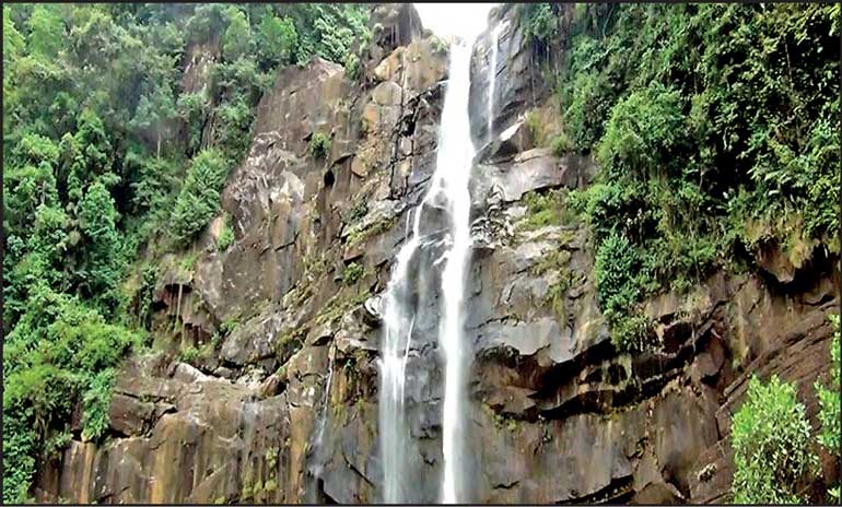
Aberdeen Falls near Ginigathena is to be developed into a tourist destination, a recent media report said. The potential to attract tourists has been realised, thus the facilities to reach the place are to be improved.
Located 5km beyond Norton Bridge passing the Hatton town, presently the picturesque 99m (322 ft) high waterfall in the Nuwara Eliya District can be approached through a somewhat rough walking track of a little over a kilometre off the Giniganthena-Ambatale Road. 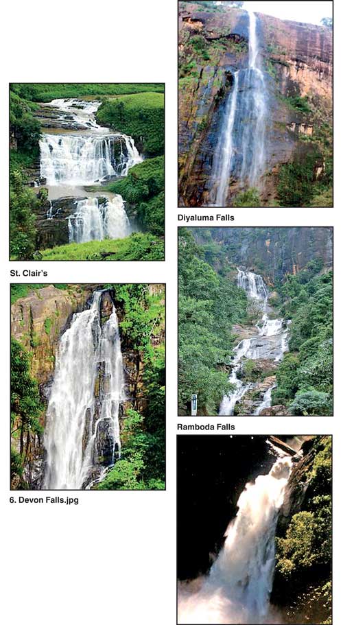
Though the waterfall has been in existence for a very long time, it had got its present name during the British administration. Aberdeen is the third largest city in Scotland. There had also been a tea plantation by the same name.
The waterfall is on the Kehelgamu Oya, a tributary of Maskeli Oya which later joins the Kelani Ganga, and its beauty is enhanced by several other minor falls nearby.
Waterfalls add a lot to the wealthy natural resources in Sri Lanka which, though small in size, boasts of nearly 400 of them – 382 to be exact, according to the Lanka Council on Waterfalls (LCWF) ), an organisation set up to improve public awareness and understanding of water issues to promote the conservation and wise use of nature and natural resources.
Bambarakada Falls (283m/863ft) at Kalupahana in the Badulla District is the highest waterfall in Sri Lanka. It is followed by Kurundu Oya Ella (Maturata Falls) at a height of 189m/620ft in the Nuwara Eliya District.
Popular visiting places
Over the years only a handful of waterfalls have been popular visiting places for tourists– more local than foreign. What is described in the article are a few which can be reached fairly conveniently.
Dunhinda, for example, is situated about 5km from the Badulla town and is its main attraction. The track was through thick forest some years back – possibly it has been done up now. Accepted as one of the most beautiful falls in the country, the water resembles a thin cloud as it cascades 63m downwards into a large pool carved out of the rocks. Meaning ‘mist/spray/vapour evaporating’, Dunhinda reflects a bridal veil.
Badulu Oya which provides the water for the falls, rises in the mountains in the south and west of Hettipola Ella bobve the Ella gap, on the border of the Uva highlands and flows into the Mahaweli Ganga. The area was once inhabited by indigenous people – the Veddas.
Diyaluma Falls, 171m/561ft high – the third tallest fall in Sri Lanka – has been one of the most popular places mainly because of its easy accessibility, being situated by the roadside along Koslanda-Wellawaya highway. Water from Punagala Oya rising in the Mahakanda Pass and flowing into Kuda Oya, a tributary of the Kirindi Ganga feeds the falls.
Folklore
Folklore play a big role as to the origin in most waterfalls.
As regards Dunhinda, the story goes of how a king had fallen in love with a low caste damsel which angered his subjects. The lovers decided to flee and once they arrived at the site of the waterfall, they began climbing. While the king reached the top the creeper that the woman was hanging on to got entangled in rocks and she plunged to her death. The tears shed by the king were collected by a deity and turned into the falls, the villagers believe.
Another version of the same story is related by eminent writer, R.L. Brohier. A young chieftain who had been banished to the highlands in attempting to get his lover to join him through the highly-guarded countryside let down a rope of twisted creepers over the cliff. As she was hauled up she was dashed against the rocks and died. The deities, moved by the tragedy, caused a steam of water to flush from the mountain and covered all evidence of the tragic happening in a watery light, thus giving the name ‘Diya-luma’.
Beautiful views
Driving along the Kandy-Nuwara Eliya highway through Gampola, Ramboda Falls can be seen from the Ramboda Pass beyond the 53rd kilometre-post. Taking the Nuwara Eliya-Pussellawa Road for 12km, the fall is located 1.5km from the highway. It is 10km from the Pussellawa rest-house, a popular place for motorists to stop for a cup of tea. The fall measures 103m/328ft and is beautiful to look at during the South-West monsoon rains when it appears as a strip of silver from a distance.
Dr. H.A.P. Abheyawardana in ‘Heritage of Kandurata’ writes: Having its origin on a plain in Central Hills, the stream takes its course through the forest cover and drops down three stages as the fall. The beautiful spray in the surrounding area appears as a cover of mist. The morning sun reflecting on the mist above the tea estates forms a rainbow.
The stream makes its appearance at a point in the Pidurutalagala range of mountain, 969.23 metres (3,150ft) above sea level providing a cool atmosphere to the tea estates. This fall joins Kotmale Oya in the Mahaweli catchment area. The second lap of the fall measures 3.38m (11ft) and the third, 110.15m (358ft).
Nuwara Eliya District’s waterfalls
Nuwara Eliya District has the most number of waterfalls in Sri Lanka. Some of them can be admired from the main highways but are difficult to reach due to lack of proper access. St. Clair’s and Devon are two pleasing waterfalls which can be observed from one spot along the Nuwara Eliya-Talawakelle Road. The aesthetic value of the Talawakele town is enhanced by the waterfalls and streams in the area.
St. Clair’s is arguably the widest waterfall in the island and is referred to as ‘The Little Niagara of Sri Lanka’. It can be seen from the Hatton-Talawakele road near the 84th kilometre post, before sighting the Devon Falls. The three tier formation and the filling of a pond by its waters is a highlight of St. Clair’s. Originating 1,000m/3,500ft) above sea level, it measures 81m/262ft. It joins a stream located in the Kotmale valley.
Devon Falls can be seen 21 kilometres along the Hatton-Talawakele road. Measuring 84.5m/318ft in height, it starts at a point 1,169m/3,800ft above sea level. Running through the ravines and spreading moisture on the tea plantations, it finally enters the Kotmale River.


