Wednesday Feb 18, 2026
Wednesday Feb 18, 2026
Tuesday, 31 May 2016 00:01 - - {{hitsCtrl.values.hits}}
The country suffered from an unprecedented drought from January to April and the populace faced the highest temperatures for decades. The monsoon was late and the arrival of rains in early May brought relief, but in a couple of weeks the relief was replaced by floods, forcing hundreds of thousands out of their homes, especially those living in low lying regions.
In addition several earth-slips in mountainous regions around Kegalle resulted in over 100 deaths and over 100 are reported missing, feared dead. The heaviest rainfall was recorded from the north-western slopes of upcountry as well as from Anuradhapura/Puttalam areas. But the most highlighted damage was due to overflowing of the Kelani River from Kolonnawa to Biyagama.
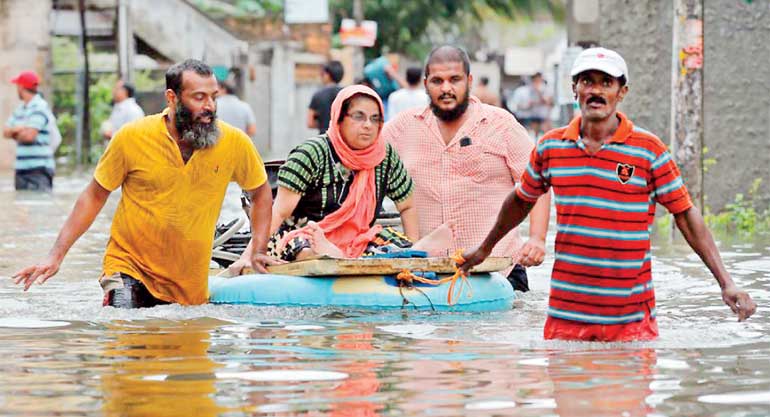 The monsoon was late and the arrival of rains in early May brought relief, but in a couple of weeks the relief was replaced by floods, forcing hundreds of thousands out of their homes, especially those living in low lying regions
Although the Kelani River was accused of causing much hardship to people, the reported rainfall in upper reaches of Kelani basin during 15 to 17 May had been around 350mm; spread over three days could be considered as high, but not very heavy.
The rainfall was due to a depression over the Indian Ocean towards North-West to the country, moving northwards and increased intensity to become the cyclone Roanu, while over India. A strong wind is considered a cyclone when the maximum sustained winds exceeds 117 kmph and when the wind speed exceeds 178 kmph is referred to as a hurricane. Sri Lanka was fortunate to experience only high winds, but India and Bangladesh were battered by the Cyclone would have suffered much heavier damage.
According to the Meteorology Department highest rainfalls recorded were”
15 Sunday – Pottuvil – 145.8 mm
16 Monday – Kilinochchi – 373.3 mm
17 Tuesday – Mahailluppeluma – 267.8 mm
18 Wednesday – Gampaha – 135.0 mm
This rainfall cannot be regarded as unduly heavy after a four-month drought. During the period Colombo received much lower rainfall and did not reach 50mm even on a single day. The heaviest rainfall recorded in Colombo had been 493.9mm in 1992 and 440.2mm in 2010.
For a heavy rainfall compare with the downpour recorded in 2004, when Deniyaya received continuous heavy rains for number of days with a peak of 782mm within 24 hours, resulting in massive floods washing off roads and bridges. But no earth-slips were recorded.
The rains received around Colombo were not heavy, but the drizzle continued almost non-stop. As shown above, Anuradhapura and Puttalam Districts received more rain and most reservoirs spilled over. The spilling of Kalawewa, Rajangana and overflowing of Malwathu Oya passing through Anuradhapura is not uncommon, as usually these reservoirs were filled with Mahaveli waters diverted from Polgolla, leaving no room to accommodate rains.
The unprecedented flooding of Kelani River was due to several reasons.
1. The hydropower reservoirs located upstream as Laksapana, Castlereigh , etc. were full and were generating maximum power, discharging water into the Kelani river.
2. The mouth of Kelani River which discharges water into the sea was blocked due to poor water out-flow during the dry months and the sea sand brought in due to wave action.
3. The large number of unauthorised housing at the river mouth did not help either.
4. Unauthorised filling of marshes and the drains and the canals that discharge rain water which were not cleared were unable to discharge to their full capacity. But the most important obstacle was the ‘Salt Water Barrier’ built across the Kelani River in 2012.
Around four years ago, Sri Lanka’s largest Kelani Right Bank Water Supply Project was constructed at Biyagama, collecting water from Kelani River. Along with the project, a Salt Water Barrier was constructed across Kelani, located just downstream of the Water Board’s Ambatale water intake. The concrete barrier several meters high commencing from the river bottom (clearly visible on Google maps) was expected to prevent entry of sea water into the water intakes of treatment plants during periods of drought.
The efficiency of the barrier was clearly experienced by the populace of Colombo and Gampaha areas, when they enjoyed continuous water on tap, even during the last dry months, while residents of Kalutara, Galle and Matara complained of their water supplied by the Water Board being contaminated with salt water.
Unfortunately, during the recent heavy rains, river water flow was obstructed by the concrete barrier, forcing the water to rise and spill over the concrete dam, thereby raising the water level in the river. It was this rise in the water level that caused the floods upstream of the Salt Water Barrier in Biyagama areas. The floods submerged poor people’s as well as expensive housing built on lands supposedly above possible flood levels and the house owners were caught unawares. The submergence was clearly visible from the Outer Circular Road. The gas tanks of LAUGFS floated, Coca-Cola and Lion Brewery in Biyagama had to stop production.
The question remains, when the Water Board planned the Salt Water Barrier, did they carry out tests and calculations of possible flooding in upstream of the barrier, especially as they were aware that the region was susceptible for flooding? In 2010 during the construction of the Water Supply Project, floods inundated the water intake and the floor levels had to be raised.
The Water Board maintains river water levels at their river intakes and they would have noticed the rise in water levels after the Salt Water Barrier. This year’s rains were much lower than 2010. Have the Water Board Engineers calculated the possible water level rise with heavier rains similar to 2010? A repetition of 2010 flood would cause inundations and damages far more severe than this year. Apparently they have not done their homework and at least at this late stage should calculate and warn people of the expected consequences. Meanwhile, Water Board Engineers should be held responsible for the damage due to negligence.
While the low-lying areas experienced floods, mountainous regions experienced earth-slips killing over 100 and another 150 bodies were not found, forcing to be categorised as missing. The earth-slips in mountains were unheard of a couple of decades ago. The earth-slips are a result of environment-damaging human actions. Decades ago, steep mountains were uninhabited and were covered with forests with no earth-slips. But the population explosion and human greed made people invade into the hills, cut slopes to construct houses and blast rocks, neglecting stability of earth slopes and the flow of sub-surface water. Large trees were cut down by the timber dealers and smaller trees by locals for house construction and as firewood. The process continued with additional clearing of jungle for cultivation purposes.
In addition, some locals set fire to jungles to hunt porcupines and wild-boars and also as a means of providing grass for their cattle; as after the fires devastated the shrubs, grass grows prolifically that could feed cattle. Villagers and the Grama Sevakas are aware of the culprits, but so far none of the vandals have been produced before a court. When wet slopes lost their retaining power due to the destruction of the vegetation root system that held the earth particles together, earth mass slips over the under-lying rock layer, creating earth-slips.
Our Meteorology Department is entrusted with the responsibility of keeping weather records and warning people of impending bad weather, but their weather statements refers only of possible rainfall over large parts of the country and warning the public to take precautionary measures to escape from possible lightning. Over the years the Department has failed to provide correct information  and is ridiculed by the public.
Internet users are surprised by how European and American companies provide detailed weather forecasts for weeks ahead, with wind direction and percentage possibility of rain for every hour, when the local Meteorology Department makes only vague statements. The website of the Met Department normally gives rainfall details of the previous day, but during the last heavy rain period, on some days the rainfall data was missing. To improve weather forecasting, in June 2009, the Department placed a purchase order for the supply of a Doppler weather radar with the Enterprise Electronics Corporation (EEC) of US at a cost of Rs. 300 million. According to the World Meteorology Organization, the Doppler weather radar is an essential precipitation (drizzle, rain, hail, etc.) observing system for large areas. The radar system was shipped to Sri Lanka in October 2011. After nearly two years of storage, the system was installed at Gongala Peak in Deniyaya. But the system failed to work and parts were sent back to the US manufacturer for repairs.
Last year Department officials, visiting the site after nearly a year, observed that the station had been ransacked, computers and valuable parts had been stolen. On investigations it was revealed that no staff nor security had been allocated to the station, apparently as the area was under the control of security forces. It is evident that five years after the massive investment, the Department is no longer interested in the weather station. The most probable reason is that the Department officials who are used to idling in their Colombo 7 office are reluctant to leave their families and assume duties on a mountain in Deniyaya.
After the floods, a Government Minister informed the press that the Japanese have expressed willingness to supply two Doppler stations to Sri Lanka. But if the country is to benefit from the system, it would be better to request the Japanese to run the system, similar to the Chinese who run the Norochcholai power plant, and close down the Meteorology Department.
During the implementation of the Weras Ganga project, severe criticism was levied by some environmentalists that due to some project canals being deeper than sea level, they would bring in sea water which would destroy crops in the lands around and during heavy rains would result in massive floods. However, after the completion of improvement of the Kesbewa Road and part implementation of the Weras Ganga project, the region that was subjected to periodic flooding even during moderate rains was spared of floods. Some politicians were on TV saying the same needs to be repeated in Kelani valley too.
The rainfall in Colombo was not very heavy and the floods were the result of unmaintained drains and canals. Also canal paths have been encroached by shanties, residents of which resisted clearing. During the last regime, clearing the canals was entrusted to security personnel, who did an excellent job but the work was discontinued by the present Government, claiming the work degrades the security forces who saved the country from the LTTE.
The Kelani River estuary is occupied by slum dwellers, depriving deploying machinery to open the river mouth. Now, the Government informs that the shanties disturbing canal paths will be relocated, the results will only be seen.
Earlier when floods hit Colombo, Kelani Bridge was full of people affected by the floods. This time refugee numbers are low, possibly most who lived in the flood-prone areas were settled in newly-built apartments. Current slum dwellers too are hopeful of apartments. But only those included in the list prepared some years will be eligible; newcomers to the slum community will not be eligible for the privilege.
Earth-slips were a result of destroying the forests covering mountainous regions. The Ministry of Environment is directly under the President and at the beginning of his term the President promised the country that he would increase the forest cover percentage. However, the Ministry failed to present any proposals to implement the intended forest cover increase.
The Forest Department is responsible for maintaining forests, but visitors notice their plant nurseries are almost bare. Over the decades, vast acreages of forests have become shrub-lands, are devoid of any valuable trees and are filled with fast-spreading foreign invasive shrubs, which cannot be consumed by cattle or elephants. Some species are full of thorns, even elephants do not dare to enter. No wonder elephants invade village gardens. The people living in steep mountainous regions need to be relocated to allow reforestation.
The spread of invasive shrubs is so destructive that the only way to improve the forests would be to engage the security forces to wage war against the invasive plant varieties and reforest the neglected lands and the mountainous regions. The invasion of destructive plants has spread throughout the country, even the marshes are not spared.
The war will not be easy to win and will would require years of ceaseless onslaught, possibly taking longer time that it took to defeat the LTTE. But the outcome would prevent any further earth-slips, flood damage, save villagers from invading elephants, result in an increase in forest quality and percentage cover, and towards achieving self-sufficiency in timber requirement.


