Sunday Jun 21, 2026
Sunday Jun 21, 2026
Tuesday, 5 January 2016 00:01 - - {{hitsCtrl.values.hits}}
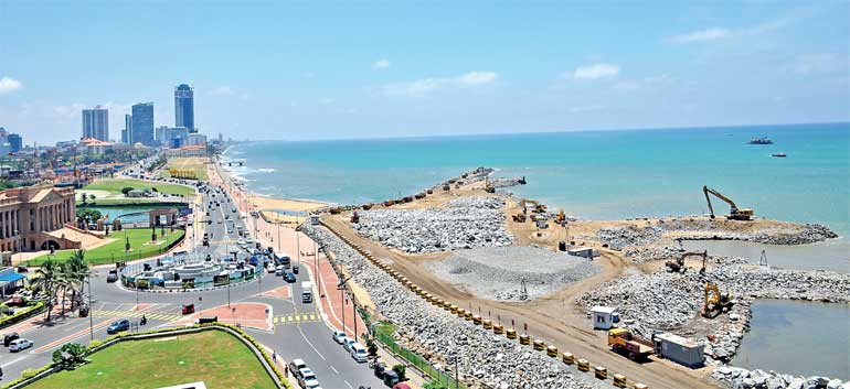
The Port City Project (PCP) commenced on 16 September, 2014, with the signing of the agreement. The construction work was ceremonially inaugurated on the same day in the presence of the President of the Peoples’ Republic of China and his Sri Lankan counterpart, during the Chinese President’s visit to Sri Lanka.
During the run-up to the Presidential Elections, the project came under heavy criticism and the new Government suspended the project. The Supplementary Environmental Impact Assessment (EIA) Report is available for public inspection since the beginning of December. This article attempts to clarify various allegations made, based solely on the environmental report, while the writer’s comments are given at the end.
Allegations
Among the allegations made against the project were:
1. The EIA approval in 2011 was for 200 ha, but was later expanded to 269 ha without reference for public comment
2. The EIA did not cover environmental impacts of sand extraction for filling
3. Extraction of sand will disturb fish breeding grounds, hence will affect fisherfolk
4. The construction will increase sea erosion
5. China would be allocated with 108 ha of land, raising concerns of security
6. Usage of reclaimed lands was not made public
History of Colombo Port City
Expansion of the Colombo Central Business District by reclaiming the sea was originally proposed under the Western Region Megapolis Regional Structure Plan in 2004, prepared by a Singapore-based urban planning consultant, CESMA International Ltd.
Accordingly, the plan proposed (a) to reclaim 145 ha of land from the sea to the south of the proposed Colombo South Port breakwater by 2010 (the current location of Colombo Port City), (b) release 76 ha from Jaye Container Terminal (JCT) to Colombo South Port, for real estate development, and (c) create 221 ha of new waterfront lands including marketable land of 139.5 ha adjacent to the Colombo Port by 2030.
The construction of the Colombo South Port in 2009, with its 5.4 km long breakwater, made reclamation of land south of the breakwater technically and financially feasible.
The Sri Lanka Ports Authority (SLPA – Project Proponent), in June 2010, commissioned an EIA study through the University of Moratuwa for the reclamation of 200 ha and the UDA completed a master plan. At the request of the SLPA, the Environment Authority appointed the Department of Coast Conservation (CCD) as the Project Approving Agency. The EIA study was accepted, being subjected to public comments in 2011. An addendum to the EIA was prepared by UoM and submitted to CCD in September 2013, increasing the reclamation area to 269 ha. This was accepted on 23 October, 2014, on condition that “a separate approval should be obtained from the CEA for extracting sand from offshore, prior to commencement of construction.”
In April 2011, China Communications & Construction Company (CCCC), the parent of the project company, submitted an unsolicited proposal. After negotiating for two-and-a-half years, in September 2014, an agreement was entered into between the project company and the GOSL to implement the project as a Foreign Direct Investment, with no guarantees by the Government. The agreement stipulates that the SLPA is responsible for securing the required environmental permits and approvals. The developer commenced reclamation immediately using sand from dredging the port access channel.
The new Government elected in January 2015, based on a report by a Review Committee (without any consultation with the project company), on 4 March, 2015, suspended the construction work of the project.
The Cabinet of Ministers in June 2015, appointed the UDA to be the project proponent, replacing the SLPA, and directed a Supplementary Environmental Impact Assessment Report (SEIAR) be prepared to address the reclamation, dredging, construction of protective structures, and extraction of sand and quarry material required for the proposed project, meanwhile, the agreement was extended in September 2015.
The project would be in two phases, Phase 1 – for reclamation, sand extraction and construction of protective structures will re‐commence upon this SEIAR receiving approval; Phase 2 – construction of buildings and infrastructure of the Port City. This EIA was based on the concept master plan submitted to the UDA while construction will commence upon receiving approval. The project will be implemented over a 25‐year period and there would be no future expansion envisaged beyond the 269 ha.
Current EIA report
The current EIA report, where public comments are sought, is referred to as the “Supplementary Environmental Impact Assessment Report”. The project proponent is the Ministry of Megapolis with the Western Development with Coast Conservation & Coastal Resource Management Department as the Project Approving Agency and the current report covers the full 269 ha.
Availability of sand for reclamation works
The quantity of sand required for reclamation is about 65 million cubic metres. The sand extraction is proposed from two sites located offshore from Dambagamawatta in Wattala to Basiyawatta in Negombo. The selected dredging areas have a generally flat, sandy seabed with hard bottom habitat while sea grass beds or coral reefs that attract fish are absent.
Sand would be extracted from two designated areas and the environmental impacts have been ascertained for these sites, which comprise a combined area of 100 sq km (46 for Site 1 and 54 for Site 2). Average water depths are about 16.5 m in Site 1 and 26 m for Site 2 and the maximum water depths are about 18 m and 36 m for Sites 1 and 2. The available sand quantity is estimated at 112 million cu m (44 for Site 1 and 68 for Site 2), or almost double the sand requirement for the completion of Port City.
The report informs that NARA was commissioned to carry out the marine ecological studies and socio-economic impacts, and LHI, who carried out studies on shoreline/coastal impacts, have recommended guidelines for dredging to minimise impacts on the coastal area, ecology and income from fisheries.
They have recommended that four modern trailing suction hopper dredgers be used while dredging should occur 3 km beyond the shoreline and at water depths exceeding 15 m. Dredging beyond 15 m depths will ensure no impact on coastal erosion and the 3 km distance will minimise impact on fishing routes and ensure no impact on “ma dal” fishing. As much as possible, dredging has to be avoided in areas which have fish spawning and unique habitats.
Independent of this SEIA, as a mitigation measure, the project proponent, has directed the SLLRDC to allow the project company to dredge sand from the 100 sq km borrow area assigned to SLLRDC for which environmental approvals have already been obtained from the CEA, estimated with dredge‐able sand quantity of 264 million cu m. SLLRDC intends to make this quantity available for purposes of Port City reclamation, pending carrying out further exploration to secure clearances from the CEA for extraction of up to 70 million cu m for use by Port City and the SLLRDC’s own use in the future.
Accordingly, the sand requirement for the Port City is only 17% of the dredge‐able sand available within the three designated borrow areas. Considering an average dredging depth of two metres, the area to be dredged will be around 40 sq km out of a total area of around 200 sq km allocated; the dredging area will be only 15‐25% of the total allocated area.
Extraction of sand will disturb fish breeding grounds
The underwater visual survey conducted in the proposed dredging sites for favourable environment for existence of fish, did not come across any form of sea-grass beds or coral in the sites or in the adjacent sea.
Fishermen, to avoid fishing in dredging areas, would have to travel further distance, leading to loss of income to fishers and a reduction in their livelihood status. The potential decrease in fish catch and landings could result in a negative impact on the local market but direct employment loss is not anticipated. It is proposed to allocate Rs. 500 million to the Ministry of Fisheries as fisher community income support.
Supply of rock
A survey by the GSMB of quarries in the Colombo and Gampaha Districts reveal the availability of 6.54 million cu m of rock and the total requirement would be met by 44% of the total mineable rock in 11 studied quarry sites. They are expected to be transported in 38 trucks (10-wheelers – 20 tonnes) and 300 trucks (six-wheelers – 14 tonnes) doing two trips per day. Although GSMB mentions Kalutara District and includes a map of quarry locations, survey results are not indicated. The transport would be over the road network in two sessions, avoiding peak hours, via six different routes to minimise traffic congestion.
Port City breakwater, with a crest level of +4.0 m sea level (allowing overtopping) in comparison to the crest level of +10.3 m Colombo South Harbour, used around 5.5 million cu m or 57% more than the total requirement of 3.5 million in material required for Port City. The quarry material already at site is around 700,000 cu m and hence the additional amount required to complete Port City is 2.83 million cu m.
The construction will increase sea erosion
The South Port Project’s 5.4 km-long breakwater extends 2 km perpendicular to the coast, which can potentially create erosion north of Colombo. However, monitoring over the last four years has confirmed erosion has not taken place. The construction of breakwater had increased the wave shadow, extending it northwards. Consequently, wave conditions had become calmer, and the shoreline between the Port and the Kelani River and beyond has remained stable after the construction of the Colombo South Port.
The development of the Port City, from the perspective of hydrodynamics, be considered as an extension of Colombo South Port. As such, the development of the Port City is not expected to cause any significant change of the shoreline.
Impact on Beira Lake
The Port City Development will probably cause impeding/silting up of the outlet location, obstructing the discharge from the Beira Lake. In order to determine the exact design, location and alignment of the proposed groyne, a preliminary study was carried out with a 200 m long groyne placed just south of the Beira outlet creating a 50 m wide outlet.
The collection of sand south of the groyne will create a beach at the Galle Face end, that can be used for recreation and water in this sheltered sea would probably be suitable for swimming and bathing.
Allocation of lands
The Port City Project would reclaim 269 ha of waterfront land and around 170 ha of land would be marketed to local and international developers. Of this, no less than 62 ha will be allocated to UDA and no less than 108 ha will be allocated to the project company.
The project agreement states that land to be sold or leased under prevailing laws of the country to third party investors for development after allowing for public parks, roads and beaches shall be no less than 170 ha. The allocation of marketable land between the project company and the GOSL would be carried out on an equitable basis where the project company will first select a land extent of less than 10 ha and then the Government will select a similar extent.
This process of alternative selections will be repeated until one party reaches the maximum marketable land allocated to that party. Therefore, the marketable lands allocated between the Government and the project company will be in non‐contiguous blocks. The public areas as roads, parks, beaches will be under the GOSL/UDA/CMC.
There will be Development Control Regulations established collaboratively with the UDA for all investors undertaking developments within CPC. This would include guidelines on maintenance of undeveloped land pending the commencement of development.
Considering a conservative base land price of $ 2,300 per square metre (Rs. 8 million per perch) and a low inflation of 3% per annum, land sales will generate about $ 6.0 billion over 20 years.
Legal position of the developed land
The Attorney General has opined that the UDA cannot be a signatory to the project agreement replacing the SLPA as it lacks the legal capacity under the UDA Act. Upon creation of new land by reclamation, the entire Port City land will be gazetted under the Sri Lanka Lands Ordinance, a subject falling under the purview of the President. Thereafter, the UDA could declare the land reclaimed by the Port City Project as an “Urban Development Area” and a declaration is made under the Lands Ordinance.
Permissible Developments within Colombo Port City
Public facilities
The Port City will have around 45 ha of public parks (nine times the size of Galle Face Green) anchored by a 22 ha Central Park offering informal grassed area, woodland and a wide range of recreational facilities. The canal area has a dock‐land with quays, bridges with wooden decks. Several parks are located along the quays, offering walk paths and enhancing accessibility to canal that allow tourist boats.
The marina and a well‐protected beach suitable for swimming and recreational activities, a lagoon and canal (for swimming, water sports and relaxation) will be features. The attraction of waterfront living will position Port City as an attractive location to “live, work and play” attracting local and foreign developers.
Employment
The direct and indirect employment potential of the project during the reclamation stage would be around 6,400 jobs representing skilled, unskilled, technical and managerial categories. The employment potential during the initial stages of the post-reclamation operations would be around 18,700, covering a wide range of occupational groups.
The predicted new job creation would be around 15,000 per annum during the first 10 years of business operations and indirect employment would be around 22,500 per annum in the first 10 years. At the end of 20 years, the total direct employed will be about 62,000 and indirect 30,000.
Implementation schedule
Port City will be implemented in three stages over a 25‐year period: (a) Reclamation and land formation (year one to three), (b) development of roads, marina, central park and landscaping (year three to four) and (c) infrastructure, roads and landscaping (year seven to nine).
Comments
The previous EIA failed to address issues regarding the extraction of sand for reclamation, the most sensitive item in the project. The responsibility of assessing the impact on the coastal sector was entrusted to the Coast Conservation Department, but their jurisdiction extended only up to 2 km from the coastline. Hence they were unable to comment on sand extraction sites.
The current report addresses environmental concerns on extraction of sand. The report comprehensively deals with particle (sand) movement in the coastal sea, wave action, sea depth and the resulting effect on the shoreline and fish breeding, due to construction. The report informs that the only effect would be for fishermen to travel further, avoiding dredging areas for fishing incurring higher expense. Their loss is being compensated by a fund of Rs. 500 million.
In procuring rock for construction, the requirement is expected to be obtained from quarries in the Gampaha and Colombo Districts. They would be transported in 338 large trucks, plying on existing roads and would result in worsening traffic conditions.
The Colombo South Harbour, used around 5.5 million cu m or 57% more than the total requirement of the Port City, where a major portion of the rock requirement was obtained from the Kalutara District. For the Port City too, prior to work stoppage, 700,000 cu m was obtained from the same source. The rock was loaded to a facility in Wadduwa and transported in barges to the Port, completely avoiding road traffic.
GSMB entrusted with locating rock requirement failed to consider Kalutara at all. In the Gampaha area, devoid of hills, the availability of rock is low. The rocks to be collected from the Colombo and Gampaha Districts amounts to 44% of the total mineable rock in quarry sites. The proposed Kandy Expressway would require a large rock quantum and diverting 44% to Port City would severely impact future rock availability for the construction industry. Whereas the mountainous Kalutara District has ample rocks and the supply chain had been established, the changeover to an environmentally damaging transport system cannot be justified.
As the environment report has pointed out, the extraction of sea-sand would not create any adverse impact on the coastal region and the breeding of fish. However, obtaining rock from the Colombo and Gampaha Districts needs to be abandoned, and reverted back to the proven method of collecting rock from the Kalutara District which should be transported in barges to the Port without disrupting road traffic.


