Monday Feb 16, 2026
Monday Feb 16, 2026
Tuesday, 6 October 2015 00:04 - - {{hitsCtrl.values.hits}}
The inaugural ArcGIS User Conference (SLAUC 2015) organised by GIS Solutions Pvt Ltd brought together the community of ArcGIS Users in Sri Lanka at a national level to enhance knowledge, highlight their work on ArcGIS platforms and educate them and their key decision makers (both public and commercial sectors) on new developments of the technology.
The attendees of 280+ GIS professionals present at the event brought leading GIS community professionals, decision makers, academia and users of Sri Lanka onto one platform providing an opportunity to network amongst peers. This event took place at the Sri Lanka Foundation Institute Conference hall, Colombo, Sri Lanka on 8 September – which was a full day’s event.
The conference also strived to build the capacity of GIS professionals in the country while creating stronger links and collaboration in the local GIS Community with showcasing of GIS projects successfully implemented by some of the leading ArcGIS community members. Furthermore promoting the effective and ethical use of spatial information and geospatial technologies that will contribute meaningfully to better understand, manage and face challenges of the nation and its citizens.

GIS Solutions Ltd., a group company of Just in Time Group, is the Sole Authorised distributor of the ArcGIS platform –developed by Esri (Environmental Systems Research Institute USA – better known by the acronym Esri). Esri too organises similar user conferences worldwide with its primary conference being the International ArcGIS User Conference which was recently held in San Diego last month with close to 17,000 registered attendees.
GIS and smart communities
GIS is a wonderful multi-faceted technology to help visualise current information and data meaningfully on a map to make better sense. A Map can tell a story that a graph or a chart may not be able to. The fact that every point on a GIS Map is linked to a database that can be immediately visualised means that data can be accessed on an device, anywhere anytime through WebGIS services to make smart decisions that are more informed, is the future.
‘Building Smart Communities’ is pertinent to Sri Lanka. Smart communities are able to leverage technology to improve the quality of life for citizens. GIS plays a critical role in this, as it empowers leaders to visualise, question, analyse, and interpret organisational data to better understand relationships and trends in their community.
The keynote address this year was delivered by Michael (Mike Quin), where he stated how smart communities is the future and how the foundation of a smart community is GIS. Furthermore, he explained how the ArcGIS software platform is able to connect all stakeholders to provide information on any device anywhere at any time. He showcased how Esri technology is at the heart of enabling smart communities with several technical demonstrations shared by his colleague Canserina Kurnia – Solutions Manager, State & Local Government to Esri Global. This was a real life example, how technology is applied to smart communities worldwide and in Sri Lanka.
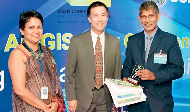
Ashani Jayasinghe, Michael Quin and Surveyor General P.M.P. Udayakantha
For a small country or island such as ours, we can greatly benefit from embracing this concept of Smart Communities and Smart Cities. It’s a means of empowering citizens with information and governments being more accountable and transparent of its actions.
The Morning Session featured presentations from prominent users from the public sector on GIS and the use of ArcGIS technology at the respective organisations as every day applications. The afternoon technical post lunch session featured presentations of selected project paper submissions based on user applications of the ArcGIS platform. These project papers will be judged by an eminent panel of GIS Experts from Sri Lanka. The six shortlisted project owners were awarded certificates and awards.
Importance of local GIS community coming together
GIS Solutions Ltd. CEO Ashani Jayasinghe welcomed the delegates and invitees with highlighting on the importance of the local GIS community coming together, as a family and as a part of a global network of ArcGIS Users. She also stated: “The best learnings and understandings in life come from your friends and family and that’s true for your GIS work too. Not only is the technology exciting but understanding the contexts within the technology applied is, and who better to learn that from than your own peers.”
“Esri is in the processes of wiring up the world digitally measuring everything that moves and changes turning it in to computational fabric about space (location), just like hundreds of years ago the invention of longitude and latitude gave us a frame work, now we are digitising that and you as professionals In many fields and many different backgrounds are leveraging that framework to do various kind of work in GIS. GIS work is pervasive, if not already it’s becoming important in every sector, for efficiency in government operations, in Economic and social development, in health, in education, in saving lives in almost everything that effects life, society and our planet. It’s important to remember not only you as an individual but you all as a network contribute positively through GIS for the future of our country and our children.”
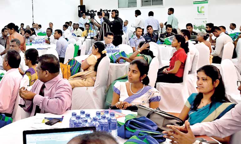
A section of the audience at the inaugural ArcGIS User Conference 2015
She also listed some of the great GIS implementations carried out such as the recent implementation of Land Information System for Sri Lanka Public by the Survey Department of SL based on ArcGIS Platform, Climate Resilience Improvement Project of the World Bank under the Ministry of Irrigation and National Water Supply and Drainage Board – World Bank projects, Business Intelligence GIS is working for Commercial CEB on ArcGS Online, the Census and Statistics Department and the Urban Development Authority, the Work Centre Research Development of MoD have done projects in these areas of public safety and emergency management .
The GIS work of the Irrigation Department which was highlighted earned a SAG award (Special Achievement in GIS Award) at the Esri International User Conference last month Held in San Diego, USA.
Jayasinghe also announced that nearly all State universities in Sri Lanka have embraced the ArcGIS platform under a special licensing scheme and University of Peradeniya and University of Moratuwa have gone one step further to arrange a University Site License program, to provide genuine software licenses for all faculties as required and for students on an on-loan basis.
Do things differently for the greater good
Dr. Vickum Senanayake, Guest of Honour at the conference, in his presentation highlighted: “It’s high time for the GIS community to collaborate and share spatial information so that GIS will truly benefit us as citizens and a nation. It’s time to breakdown the silos and other structures that the GIS community currently operates in and really enable the nation to reap the full potential of GIS in every area.”
He went to share the example of how utilities organisations are having issues protecting their network-related assets and other infrastructure with the current road excavations that are taking place and how if a proper GIS system was in place disruption and destruction to these assets could have been avoided. He challenged the GIS community to move out of their comfort zone and do things differently for the greater good.
Collaborative working
Muhuthan Canagey, CEO, ICTA, who was the Chief Guest for this occasion, shared: “Technology disruption is taking place all over the world; for it to take place the support of the policymakers is an essential part, to bring about an environment that fosters such organic disruption. Now, you have it.”
He also stated that the Government is very keen on developing soft infrastructure and the ICTA has identified the need to have a complete centralised Government cloud to store large amounts of data, share and transfer files and real-time information with private and public sectors as well as citizens. This will be the first time the Government will be building a big data vault.
He added: “Our competition is no longer local, it is global. In Sri Lanka, technology is available and it can be accessible, but we haven’t changed our culture of collaborative working. If we fail to meet the global competitive world, our industry will not last. In Sri Lanka, we, have failed to achieve global position in many areas; but we should not fail in the technology space. Policymakers specifically in digitisation space are forced to change as our youth are demanding for change at a pace that has never ever been demanded. The political mindset also has to change in order to make sure these initiatives are implemented effectively. You have the support of the policymaker and now it is for you to change in the areas of collaborative working.”
The Surveyor General P.M.P. Udayakantha, Dr. A.J. Satharasinghe – Director General of the Census and Statistics Department of Sri Lanka and Pushpa Gamage, Director IS and GIS – Urban Development Authority of Sri Lanka were also among the key presenters contributing to the use of GIS technology in their work as a decision support tool and a planning and asset management tool.
Global Disaster Risk
Analysis Prevention and Mitigation App
The team from the Centre of Research and Development which included Lt. Col. Rasika Kahadagamage did a presentation and demonstration on ‘Global Disaster Risk Analysis Prevention and Mitigation Application, to fulfil any global disaster requirements’.
The application has been developed using world most advanced mobile web and live tracking technologies to address the bottlenecks of disaster mitigation efforts by the Sri Lankan armed forces in the past including Nepal earthquake devastation. Research span of the Centre for Research and Development – Ministry of Defence is not limited to defence applications but it covers all most all the field of modern technologies including disaster management.
Sri Lanka is home to an estimated 15,000+ GIS professionals and users which have been used in the country for over two-and-a-half decades across varied levels. The fact that universities across the country offer postgraduate courses in GIS highlights GIS’ standing in the nation.
GIS Solutions Ltd. is a subsidiary of Just In Time Group and is the sole authorised distributor in Sri Lanka to market the ArcGIS range of GIS Technology products, appointed by the global GIS Technology leader ESRI (Environmental Systems Research Institute).
Just in Time Group, with many leading specialised industry related principal relationships in place, is focused in the areas of strategic ICT solutions, core ERP and CRM solutions, systems integration services, infrastructure solutions, and strategic ICT investments, targeting the banking and financial services industry, telecommunications, government, defence and commercial vertical sectors.


