Friday Feb 27, 2026
Friday Feb 27, 2026
Wednesday, 2 September 2015 00:00 - - {{hitsCtrl.values.hits}}
 None of the review reports recently undertaken by the Government has identified coastal erosion resulting from the Port City construction
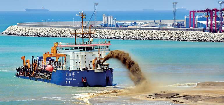
- Pic by Lasantha Kumara
Sri Lanka has a lengthy coastline of 1,585 km and in the recent years, it has been estimated that over 50% of the shoreline is subject to or at least threatened by coastal erosion. This can be attributed to both wind and water action as they play an important role in causing coastal erosion.
Both wind and water actions are the reasons as to why there is a constant change in the boundary between land and water as well. In short, coastal erosion is defined by the action that takes away land from one area and deposits it somewhere else.
National sand studies done in Sri Lanka in the ’90s by both Delft Hydraulics and the University of Moratuwa, together with work done by the late Dr. Hanno Scheffe for the Coast Conservation Department (CCD), followed by a deeper study by Bandula Wickramarachchi, also of the CCD, observed that if erosion is to aggravate in the island nation, it has to be due to reduced sand supply moving from the south to the north of the coastal lines, increase in wave height and/or change in wave direction resulting in greater deposit transportation, or construction of a littoral barrier (a barrier constructed to protect the land from the sea).
Historically, erosion between the coastal lines of Panadura and Mount Lavinia took place due to river training work at Panadura which acted as a littoral barrier. The CCD had to develop solid revetments between Panadura and Ratmalana in the late ’80s to ensure the protection of the rail line. There have been recent developments along the Panadura coast line in order to construct a fishery harbour and it is important to revisit the structures and examine whether their capacity as littoral barriers have increased. As any reduction in the deposit supply will lead to erosion.
No new construction of littoral barriers has taken place between Panadura and Colombo Fort apart from the Colombo South Harbour (CSH), which was completed in 2010, located on the sea side of the old Colombo Harbour. The CSH was the largest intervention on the coast of Sri Lanka with an east- west breakwater, vertical to the beach, extending more than 1.5 km. The project was based on extensive design studies which proved successful. The CSH has been positioned as the best transhipment cargo handling hub in the South Asia region.
Following this project, an overload of sediment discharge from the Kelani River nourished the beaches north of Colombo supported by robust coast protection work constructed by the CCD. No major erosion was observed north of Colombo. Erosion may have taken place if the Kelani River could not match the deposits blocked by the new harbour. Since the dominant direction waves is from the south west, it was expected that over time sand would naturally accumulate up drift of the 1.5 km long breakwater, at the proposed location of the newly proposed Colombo Port City project. Long term monitoring has proved that the CSH has performed well.
Ideal location
Sri Lanka’s multi-billion dollar mega Port City project is constructed south of the east-west breakwater of the Colombo South Harbour (CSH). The location where the Port City is to be constructed is where there will be a natural accumulation of sand, south of the east-west breakwater (around 1.5 km in length) of the CSH. It is for that reason that this location had been identified for Port City type of development by all development plans including the Confederation of European Shipmasters’ Associations (CESMA) Plan.
Globally, this type of location is used for reclamation projects on large and small scale. The development of the Port City will in no way create a littoral barrier. The barrier itself is already present via the east-west breakwater of the CSH. Undertaking reclamation in an area where sand will naturally accumulate with time is a very popular practice in coastal engineering and not challenging.
Furthermore none of the review reports recently undertaken by the Government has identified coastal erosion resulting from the Port City construction. Even in articles critical of the Port City written by coastal engineers, it has been recognised that erosion is not an issue. For example to quote a local media report which was published recently –“There are no significant issues related to the proposed location of the Port City with regards to long shore sediment movement and erosion. The Colombo South Port offers partial shelter and, hence, there can be optimisation of the cost of marine protective structure.”
No adverse erosion effects
According to Senior Engineer H.N.R. Perera, the construction of the Port City would not have any adverse erosion effects as the project was positioned in an ideal location, close to the breakwater of the CSH.
“The proposed development of the Port City is in the shadow of the newly constructed approx. 5km south breakwater of the Port of Colombo called the South Harbour breakwater. This construction was carried out and completed around four years ago, and had undergone a complete Environment Impact Assessment (EIA) with specific emphasis of possible impacts to the adjacent coast,” Perera said.
He explained that coastal engineering proven basic fundamentals show that coastal erosion is limited to natural geomorphological barriers such as headlands, harbours, and river mouths, etc., commonly known as littoral barriers.
He further noted that all observations made after the construction of the breakwater both south as well as north side; do not pointedly show that there have been any impacts on the coastline. It is also of note that large scale coastal stabilisation schemes were implemented north of the harbour (Crow Island, Usketiyawa) where the erosion that was prevalent was curtailed in 2005-2007, he added.
“In the present context, there have been locations where there has been severe erosion such as Marawila, Wennapuwa, Payagala, Beruwala, and further down south. In all these areas, state-of-the-art preventive measures has not only curtailed erosion but created a beach. In the context of Sri Lanka coastline, all beaches are replenished by sand brought down from the hinterland along the rivers. No sand in deep water could come back onto the coastline unless artificially brought back,” the Senior Engineer said.
Observations from Google Earth (historical images) do not indicate a major problem which has arisen due to the long perpendicular breakwater of the CSH. Images from September 2009 to August 2014 provide good evidence of a good design.
Historically there have been many instances where increased wave activity (changes in height and approach angle of the waves) over short periods of time has caused significant movement of the sand, leading to erosion. Since the Sri Lanka Port’s Authority (SLPA) is monitoring wave heights continuously at the Colombo Harbour via Lanka Hydraulics Institute, this is a great advantage and should be made use of at the very earliest to understand any problem.
Global rise in dredging and reclamation
Globally, dredging and reclamation has increased tremendously over the last few decades in particular for port/industry related development and even for leisure and lifestyle. The Palm City in Dubai and the Wave City in Muscat are examples of the latter.
The least challenging of this type of dredging and reclamation projects is the Port City type where reclamation is carried out under the shadow and up drift of a breakwater where sand would anyway accumulate with time. But there are many examples of innovative reclamation projects which have been successfully undertaken on a global scale by countries small and large.
Small countries such as Singapore and even Maldives have increased its land mass foot print by reclamation. Countries such as Japan have generated large extents of port related industrial development by planned reclamation. A short visit south of the Tokyo bay towards Yokohama reveals miles of reclaimed areas successfully utilised for port/industry related development.
With global warming, sea levels have risen and there have been changes in weather. Due to this, there are many challenges faced by small island states where the large proportion of the population will have to be relocated. In the absence of land in their own countries and unwillingness of other nations to accommodate them, there will be no option but to create well designed protected artificial islands having a very safe elevation to solve these types of problems.
How to provide greater protection to existing islands and create safe protected islands in the future are some of the problems that Small Island Developing States (SIDS) face in the future.

